Saving Seafood

  • Home
  • News
    • Alerts
    • Conservation & Environment
    • Council Actions
    • Economic Impact
    • Enforcement
    • International & Trade
    • Law
    • Management & Regulation
    • Regulations
    • Nutrition
    • Opinion
    • Other News
    • Safety
    • Science
    • State and Local
  • News by Region
    • New England
    • Mid-Atlantic
    • South Atlantic
    • Gulf of Mexico
    • Pacific
    • North Pacific
    • Western Pacific
  • About
    • Contact Us
    • Fishing Terms Glossary

BOSTON HERALD: ‘Monument’ plan dries up

April 4, 2016 — It turns out there are limits to how far even the Obama administration will go to please the green lobby. The White House has opted not to designate an area of the Atlantic off Cape Ann as a national monument, which would have closed it to commercial fishing and activities such as oil or gas exploration or extraction — permanently.

Gov. Charlie Baker last fall had written to President Obama of his objections to the pending national monument designation for Cashes Ledge and a second area known as the New England Canyons and Seamounts, largely because of the unilateral nature of the decision. Some members of the state’s congressional delegation had also raised concerns.

Commercial fishing is already restricted around Cashes Ledge, an underwater mountain range. The monument designation was expected to make those restrictions permanent, but the White House Council on Environmental Quality told a gathering of fishermen and regulators March 24 that Cashes Ledge is no longer being considered (no decision has been made on the other area).

Read the full editorial at The Boston Herald

Environmental groups release scientific analysis of areas proposed for Atlantic marine monuments

March 29, 2016 – WASHINGTON (Saving Seafood) – This morning, the “Protect New England’s Ocean Treasures Coalition” released an analysis of Northeast ocean areas under consideration for designation as marine National Monuments. The analysis was conducted by Dr. Peter Auster of Mystic Aquarium and Dr. Scott Kraus of the New England Aquarium, and was presented in a press webinar organized by the Pew Charitable Trusts.

Dr. Auster and Dr. Kraus concluded, among other findings, that the proposed monument areas possess high habitat diversity and an abundance of species, function as a source of habitats including for commercial species, and contain species sensitive to disturbance. However, they noted that they do not have adequate data to address what the economic and human effects of area closures to fisheries might be. Presenters also acknowledged that the areas under consideration are already protected, but expressed concern about the future possibility of drilling and mining.

A monument designation would likely affect the fisheries for Atlantic red crab, offshore lobster, squid, mackerel, butterfish, tilefish, albacore wahoo, dolphinfish (mahi mahi), and others. Pelagic longline, rod and reel, and greenstick fisheries including yellowfin tuna, bluefin tuna, bigeye tuna, and swordfish may also be affected. During the webinar, the presenters conceded that they do not have enough data to analyze how a monument designation would affect many of these fisheries.

The analysis addressed both Cashes Ledge and the Northeast Seamounts and Canyons. White House officials stated last week that Cashes Ledge is “not under consideration for a [national monument] designation at this time.” However, representatives of the Northeast Seafood Coalition and Associated Fisheries of Maine, who attended meetings with White House officials, said in a joint statement that offshore canyon areas east of Cape Cod remain under consideration and “affected fishermen should remain vigilant in assuring that any concerns they may have are addressed.”

The Protect New England’s Ocean Treasures Coalition, which “is advocating for the establishment of a Marine National Monument in the North Atlantic Ocean,” is composed of:

  • Center for American Progress
  • Conservation Law Foundation
  • Environment America
  • Mystic Aquarium
  • National Geographic Society
  • National Wildlife Federation
  • Natural Resources Defense Council
  • New England Aquarium
  • Ocean Conservancy
  • Oceana
  • The Pew Charitable Trusts

Read a fact sheet about the proposed Atlantic monument areas

Captions courtesy of Pew Charitable Trusts

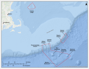
Proposed NE monument

Proposed Marine National Monument in Northeastern Waters of the U.S.

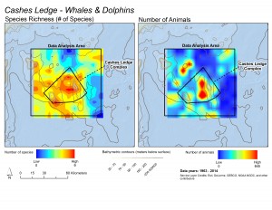
These maps illustrate that while whale and dolphin species are distributed throughout the whole Cashes Ledge region, the deep water toward the center of the proposed monument area is a hot spot for both the total numbers of species (left) and the total numbers of animals (right). Courtesy of Scott Kraus and Brooke Wikgren, New England Aquarium

These maps illustrate that while whale and dolphin species are distributed throughout the whole Cashes Ledge region, the deep water toward the center of the proposed monument area is a hot spot for both the total numbers of species (left) and the total numbers of animals (right). Courtesy of Scott Kraus and Brooke Wikgren, New England Aquarium

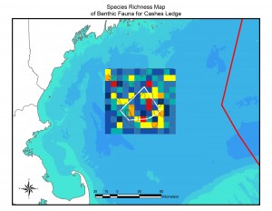
This map illustrates the pattern of species richness (number of species) of bottom-dwelling animals in the Cashes Ledge area. Warmer colors indicate more species. The largest red diversity hot spot is the peak of Cashes Ledge, where the largest continuous kelp forest on Cashes Ledge is located. Note that this map displays number of species, not numbers of individuals or density of animals. Courtesy of Peter Auster and Michel McKee, Mystic Aquarium

This map illustrates the pattern of species richness (number of species) of bottom-dwelling animals in the Cashes Ledge area. Warmer colors indicate more species. The largest red diversity hot spot is the peak of Cashes Ledge, where the largest continuous kelp forest on Cashes Ledge is located. Note that this map displays number of species, not numbers of individuals or density of animals. Courtesy of Peter Auster and Michel McKee, Mystic Aquarium

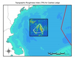
Topographic roughness – essentially, small-scale bumpiness of the seafloor – is linked to the distribution and diversity of microhabitats that in turn support a diversity of species. Warmer colors indicate greater "roughness" and are linked to locations of species-rich communities. For example, the area of high roughness on the top of Cashes Ledge (right inside the proposed monument boundary) is where the kelp forest is located and a species diversity hotspot. Courtesy of Peter Auster and Michel McKee, Mystic Aquarium

Topographic roughness – essentially, small-scale bumpiness of the seafloor – is linked to the distribution and diversity of microhabitats that in turn support a diversity of species. Warmer colors indicate greater “roughness” and are linked to locations of species-rich communities. For example, the area of high roughness on the top of Cashes Ledge (right inside the proposed monument boundary) is where the kelp forest is located and a species diversity hotspot. Courtesy of Peter Auster and Michel McKee, Mystic Aquarium

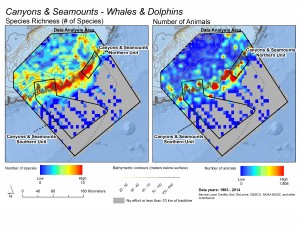
These maps illustrate patterns in the richness of species (left) and total numbers of whales and dolphins (right) observed during surveys in the Northeast Canyons and Seamounts region. Warmer colors indicate greater richness or abundance. Note how species concentrate on the eastern Georges Bank, where the shelf descends into the deep ocean, and hot spots for concentrations of whales and dolphins dot the shelf-edge. Courtesy of Scott Kraus and Brooke Wikgren, New England Aquarium

These maps illustrate patterns in the richness of species (left) and total numbers of whales and dolphins (right) observed during surveys in the Northeast Canyons and Seamounts region. Warmer colors indicate greater richness or abundance. Note how species concentrate on the eastern Georges Bank, where the shelf descends into the deep ocean, and hot spots for concentrations of whales and dolphins dot the shelf-edge. Courtesy of Scott Kraus and Brooke Wikgren, New England Aquarium

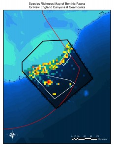
This map shows hot and cold spots for species of bottom-dwelling animals in the New England Canyons and Seamounts areas. Species are especially diverse along the edge of Georges Bank, where the shelf descends into the deep ocean. Hot spots are also visible on Bear, Physalia, Retriever and Mytilus Seamounts. Courtesy of Peter Auster and Michel McKee, Mystic Aquarium

This map shows hot and cold spots for species of bottom-dwelling animals in the New England Canyons and Seamounts areas. Species are especially diverse along the edge of Georges Bank, where the shelf descends into the deep ocean. Hot spots are also visible on Bear, Physalia, Retriever and Mytilus Seamounts. Courtesy of Peter Auster and Michel McKee, Mystic Aquarium

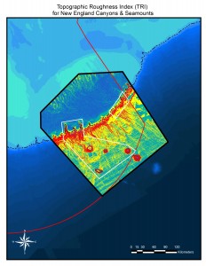
Topographic roughness – essentially small-scale bumpiness of the seafloor – is linked to the distribution and diversity of microhabitats that in turn support a diversity of species. Warmer colors indicate greater "roughness" and are linked to locations of species-rich communities. A high topographic roughness value suggests where especially rich communities may be found. The entire shelf-edge, where Georges Bank descends into the deep ocean, is topographically rough, and Bear, Physalia, Retriever and Mytilus Seamounts stand out. Courtesy of Peter Auster and Michel McKee, Mystic Aquarium

Topographic roughness – essentially small-scale bumpiness of the seafloor – is linked to the distribution and diversity of microhabitats that in turn support a diversity of species. Warmer colors indicate greater “roughness” and are linked to locations of species-rich communities. A high topographic roughness value suggests where especially rich communities may be found. The entire shelf-edge, where Georges Bank descends into the deep ocean, is topographically rough, and Bear, Physalia, Retriever and Mytilus Seamounts stand out. Courtesy of Peter Auster and Michel McKee, Mystic Aquarium

Why Gulf of Maine waters won’t be a national monument

March 28, 2016 — Despite substantial pressure from environmental groups, Obama administration officials this week said the president won’t declare a national monument in a distinct portion of the Gulf of Maine that features glacier-sculpted mountain ranges and billowy kelp forests.

Over the past year, environmental advocates have lobbied the administration to designate an area known as Cashes Ledge as a national monument, a decision that would have permanently banned fishing around the submerged mountain range.

The ecosystem, about 80 miles off the coast of Gloucester, is home to an abundant array of life, from multicolored anemones to massive cod. Fishermen have opposed the designation and said they were relieved when they learned about the decision in meetings this week with officials with the White House Council on Environmental Quality.

Read the full story at The Boston Globe

MASSACHUSETTS: A National Marine Monument for New England? Maritime Gloucester Talk

March 23, 2016 — A National Marine Monument for New England. Should the President designate the Cashes Ledge Closed Area and the New England Coral Canyons and Seamounts as the first Marine National Monument in the Atlantic? Come and hear experts Vito Giacalone from the Northeast Seafood Coalition and Peter Shelley of Conservation Law Foundation tackle the issues and the controversies surrounding Presidential action. A Panel with Vito Giacalone, Volunteer Chair of Governmental Affairs, Northeast Seafood Coalition and Peter Shelley, Senior Counsel, Conservation Law Foundation Massachusetts, with moderator, Sean Horgan, Gloucester Daily Times. Recorded at Maritime Gloucester on 3/3/2016

Watch the full video at Cape Ann TV

Obama to Designate New National Monuments; Atlantic Monument Still Under Consideration

February 12, 2016 — The following is an excerpt from a story by Juliet Eilperin, Washington Post White House bureau chief, who addresses new national monuments to be declared this week, and mentions possibilities for additional designations before the end of the Obama Administration including New England corals, canyons, and seamounts, and an expansion of Papahanaumokuakea in the Pacific.

“We have big, big ambitions this year, so let’s see what happens,” said Christy Goldfuss, managing director of the White House Council on Environmental Quality, adding that the administration is focused on “local requests for action. It’s really been driven by activities on the ground.

The big question: What next?

Other possible future designations include Bears Ears, a sacred site for several Native American tribes in southeastern Utah; Stonewall, the site of a 1969 inn riot by members of New York City’s gay community; the New England Coral Canyons and Seamounts; the historic headquarters of the National Woman’s Party, Sewall-Belmont House in Washington, D.C.; and Nevada’s Gold Butte, an area where rancher Cliven Bundy and his supporters have defied federal authorities.

It is less clear what Obama will do in federal waters, where nearly all of the strict protections are in the central Pacific. There are a group of Hawaiians lobbying the president to expand Papahanaumokuakea – a monument George W. Bush created a decade ago, whose islands and atolls are home to 1,750 marine species found nowhere else on Earth – to the full extent under the law. That would make it 520,000 square miles, or nine times its current size.

“Some people here are working here to provide the president with a legacy opportunity,” said William Aila Jr., looking down from a rocky outcropping in Oahu as two endangered Hawaiian monk seals nestled below. “It would be the largest marine protected area for a long, long time. It would be almost impossible to top it.”

Read the full story at the Washington Post

Feds approve exemption of US longline vessels in American Samoa Large Vessel Prohibited Area

February 1, 2016 — The following was released by the Western Pacific Regional Fishery Management Council:

Federally permitted longline vessels in American Samoa that are over 50 feet in length can fish for pelagic species in certain areas of the American Samoa Large Vessel Prohibited Area or LVPA. The National Marine Fisheries Service announced the final rule, which will publish in the Federal Register on February 3, 2016.

The LVPA, which extends out to 30 to 50 nautical miles from shore around the islands of American Samoa, prohibits vessels greater than 50 feet from fishing within the area. In 2015, the Western Pacific Regional Fishery Management Council undertook decision-making to amend the applicable federal LVPA regulations to provide an exemption to large vessels in the American Samoa longline fishery to allow them to fish seaward of 12 nautical miles from shore around the islands of Tutuila, Swains Island and the Manu’a Islands. Fishing around Rose Atoll Marine National Monument remains unchanged

The LVPA was developed by the council and approved by the National Marine Fisheries Service in 2002 to prevent potential gear conflicts between large and small fishing vessels. At that time, approximately 40 alia longline vessels were operating in offshore waters around American Samoa. Originally used to target bottomfish, the alia vessels range from 25 to 40 feet in length and have a catamaran hull.

Since 2002, the alia longline fleet in American Samoa declined to the point where only one alia longline vessel was operating in recent years. In 2014, the council proposed opening the LVPA as a means to assist the larger U.S. longline vessels based in American Samoa. The U.S. fleet was experiencing financial difficulties attributed in part to market competition resulting from an influx of Chinese longline vessels in South Pacific albacore fishery. In making its decision, the council noted that the National Standards of the Magnuson-Stevens Fishery Conservation and Management Act require the achievement of optimum yield and the fair and equitable allocation of privileges. The council took final action on the measure in March 2015. The exemption will be reviewed annually by the council to take into consideration any new small vessel fisheries development initiatives, small vessel participation and catch rates.

Council Chair Edwin Ebisui Jr. noted that the measure is important to maintain the supply of U.S. caught albacore from the local longline fleet to the Pago Pago-based canneries in American Samoa. The exemption will improve the viability of the American Samoa longline fishery and achieve optimum yield from the fishery while preventing overfishing.

The Western Pacific Regional Fishery Management Council was established by Congress in 1976. Under the Magnuson-Stevens Fishery Conservation and Management Act, the Council has authority over the fisheries in the Pacific Ocean seaward of the state/territory waters of Hawaii, American Samoa, Guam, Commonwealth of the Northern Mariana Islands and the U.S. Pacific Remote Island Areas.

Read the release online here

Water, Power and Oceans: A Year in Review – Protecting and Promoting Fishing Access

December 21, 2015 — The following was released by the House Subcommittee on Water, Power, and Oceans:

Through conducting oversight of the Obama Administration’s actions and through key marine resource management reforms, Subcommittee Republicans remain dedicated to preserving American’s access to our domestic offshore waters.

In June, the House of Representatives passed H.R. 1335, the “Strengthening Fishing Communities and Increasing Flexibility in Fisheries Management Act.” This bill, introduced by Rep. Don Young (AK-At Large), makes key reforms to the Magnuson- Stevens Act – the primary law regulating federal fisheries management. H.R. 1335 increases transparency in federal fisheries agency decisions, empowers regional decision-making, and improves recreational fishing data and access through requiring state data into federal assessments. The bill also ensures access to marine resources by affirming that the Magnuson-Stevens Act shall remain the ultimate authority over federal fisheries management even within the bounds of a Marine National Monument or Marine Sanctuary. Hundreds of organizations support the bill, which is pending in the Senate.

Despite National Park Service estimates on low fish availability, Chairman Bishop and his crew caught 48 fish in 70 minutes in Biscayne Bay, Florida. Source: House Natural Resources Republicans

Gaps in fisheries science and management decisions are not the only issues impacting access to marine resources. This past year alone, the Administration has entertained a series of executive actions and agency rules that inhibit fishing access, often without even securing the support of local entities or states.

This was apparent in June when the National Park Service released the final General Management Plan for Biscayne National Park in Florida, which included 10,502 acres in state waters that would be closed to all commercial and recreational fishing – despite opposition from the State of Florida and others. In August, the House Committees on Natural Resources and Small Business held a joint oversight field hearing in Homestead, Florida to review the plan.

Highlighted in this hearing was H.R. 3310, a bill introduced by Rep. Ileana Ros-Lehtinen (FL- 27) that aims to avoid future situations like the one in Biscayne National Park by preserving a state’s right to manage the lands and waters within their jurisdiction. The text of H.R. 3310 was incorporated into H.R. 2406 in October by an amendment offered by Rep. Amata Radewagen (American Samoa). A number of fisheries organizations supported the amendment and H.R. 3310. You can find more information about this amendment and the markup here.

The Administration is considering additional ideas to close off further access. In September, the Subcommittee held an oversight hearing on a proposal being considered by the Administration to create the first Marine National Monument in the Atlantic, off of the coast of Cape Cod, Massachusetts. During this hearing, Subcommittee members heard of a September 15 Town Hall meeting hosted by the National Oceanic and Atmospheric Administration (NOAA), which one witness characterized as a “charade,” as so few details regarding Representatives Lee Zeldin and Tom the proposal  had been made public at that time. Full Committee Chairman Bishop and Subcommittee Chairman Fleming and others subsequently sent a letter to NOAA and the Council on Environmental Quality echoing bipartisan requests for additional information regarding the proposal as well as additional opportunities for local input. Three months after the Town Hall meeting, the Administration has yet to release any additional information, including coordinates or maps, of the designation under consideration.

Representatives Lee Zeldin and Tom MacArthur and Chairman Rob Bishop in Long Island, New York. Source: House Natural Resources Republicans

The economic impacts of the potential Marine National Monument were also discussed at a December oversight field hearing in Long Island, New York, where the Natural Resources Committee and Rep. Lee Zeldin (NY-01) heard firsthand about the impacts of federal decision-making on public access and regional economies. This hearing highlighted the crucial reforms to federal fisheries management made by H.R. 1335 and the assurances that these provisions would give to the recreational and commercial fishing industries. Witnesses from the local commercial, recreational, and charter-for-hire industries expressed their support for reforms within the bill that increase transparency in federal decision-making and require greater incorporation of state and regional input.

The Subcommittee has also held hearings on specific bills aimed at regional fisheries issues in 2015. During a July 23 legislative hearing, the Subcommittee heard from fishermen, tribes, and the Administration about two necessary bills introduced by Rep. Jamie Herrera Beutler (WA-3) to preserve fishing access on the west coast: H.R. 564, the Endangered Salmon and Fisheries Predation Prevention Act of 2015, and H.R. 2168, the Dungeness Crab Management Act. To assist the recovery of Endangered Species Act (ESA) listed salmon in the Columbia River watershed and to protect tribal ceremonial, subsistence and commercial fisheries, H.R. 564 authorizes the U.S. Secretary of Commerce to issue expedited permits authorizing states and tribes to lethally take non-ESA listed sea lions under certain conditions. Fishermen and tribal leaders testified that this additional authority was necessary as sea lions have inhabited the lower Columbia River and have been ravaging ESA listed species of chinook, steelhead, coho, and chum salmon. During this hearing, the Subcommittee also heard unanimous support from the panel of witnesses for H.R. 2168, a bill to make permanent the long standing tri-state (Washington, Oregon and California) Dungeness crab management authority in place since 1980. H.R. 2168 passed the House of Representatives on October 6 and is pending in the Senate.

Sea Lion eating ESA listed Salmon in the Lower Columbia River. Source: Columbia River Inter-Tribal Fish Commission

The Subcommittee also held a hearing on H.R. 3094. As introduced by Rep. Garret Graves (LA-06) and others, the bill transfers the management authority of the red snapper fishery in federal waters from NOAA to a new authority comprised of a representative of each of the five Gulf of Mexico States in response to concerns over federal accountability, decisionmaking and access. The Subcommittee heard from a wide array of witnesses representing different user groups, including States, recreational industry, commercial and charter fishermen, and restaurants.

View a PDF of the newsletter

Fishing industry, environmental groups spar over protected areas in Atlantic waters

November 21, 2015 — NEW BEDFORD, Mass. — A growing effort to permanently protect deep-sea canyons, mountains and ledges in waters off New England has the local fishing industry on edge.

“It would be a big hit for the company,” Jon Williams, president of Atlantic Red Crab Co. on Herman Melville Boulevard, said about the potential for the first marine protected areas on the Eastern seaboard. “We’re going to lose an area that we fish regularly, and we’re going to lose it forever.”

There’s a big “if” behind Williams’ statement. Environmental groups and marine scientists have intensified their calls in recent months for President Barack Obama to declare “national monument” status for three ocean areas, which would permanently protect them from an array of commercial and industrial uses. No decision has been reached, though, and the timetable for action could extend over Obama’s last year in office.

That could make 2016 a nervous year for fishing industry leaders and advocates in New Bedford and elsewhere on the New England coast.

“I am strongly opposed to the national monument,” Stephanie Rafael-DeMello, co-owner of Bela Flor Seafood Brokerage Co. and manager of Northeast Fishery Sector 9, said in an email. “I believe it takes away from the public, science-driven process that goes into such considerations.”

After a flurry of activity this fall, the issue is stirring broad debate about how to balance preservation of marine life, ocean health and sustainable fisheries with potential oil and gas exploration, unsustainable fisheries, mineral mining, fishing-reliant regional economies and more.

Also at issue is how the protected national monument areas could be established. Backers of the effort are urging Obama to use the Antiquities Act, which dates to 1906 and allows the president to act unilaterally to preserve endangered areas. People opposing or questioning the monument effort, though, say use of that act could circumvent public input.

“The problem is it doesn’t use the normal process, which is the New England Fishery Management Council, to open or close (ocean) areas,” said Ed Anthes-Washburn, executive director of the Harbor Development Commission.

Mayor Jon Mitchell expressed similar concerns.

“National monuments are declared by the White House without the same kind of vetting that NOAA applies to new regulations,” Mitchell said last week. “We’ve been making the case that the federal government needs to put the brakes on the declaration of a national monument over an area that has extensive sea canyons and sea mountains, which is a place that’s fished primarily for ocean crabs.”

Priscilla Brooks, vice president and director of ocean conservation for the Conservation Law Foundation (CLF), a Boston environmental advocacy group, said about 800,000 square miles in the Pacific Ocean already have been protected as marine national monuments.

Obama established three of those Pacific monuments by presidential proclamation in January 2009, and a fourth was established in 2006, according to the National Oceanic and Atmospheric Administration (NOAA).

“We don’t have a single mile in the Atlantic. Not one,” Brooks said. “We think it’s time.”

Read the full story at the New Bedford Standard – Times


NOAA encourages continued engagement on possible marine protected areas in New England

October 29, 2015 — The following was released by NOAA:

We would like to thank those of you who have taken the time to engage with NOAA on possible protections for some of the most ecologically important areas in the Atlantic Ocean, including several deep sea canyons and seamounts. We are committed to evaluating opportunities to protect important marine resources and habitat, while limiting impacts to those people and businesses whose livelihoods depend on these waters.

We received a lot of valuable input at the town hall meeting and have received many helpful comments and questions submitted electronically.

Many of you have requested more details and additional opportunities for public comment, and in the coming months we intend to release additional information about the area under consideration and solicit feedback.

In the meantime, if you have more thoughts that you would like to share, please continue to send them to:  atlanticconservation@noaa.gov.


NEW BEDFORD STANDARD-TIMES: Fishermen win a small victory

October 8, 2015 — Fishermen in the Northeast fisheries can celebrate a small victory in what President Obama didn’t do on Monday.

The president addressed, by video, attendees of the Our Ocean 2015 conference in Valparaiso, Chile, and announced two new marine sanctuaries, neither one of them off the coast of new England.

Commercial fishing advocates had been fighting to counter the message of environmental groups that were running a full-scale campaign to put Cashes Ledge and the New England Canyons and Seamounts on the list, along with the two announced by the president in Maryland and Lake Michigan.

New England fishermen looked at the 6,000 square miles under consideration off the coast and saw the next strategic step toward pushing them off the ocean.

The valuable cold-water kelp forests of Cashes Ledge and the coral fields in the five canyons and four seamounts are worthy of protection, but they are already off limits to fishermen.

Fishing advocates’ concern of “policy creep” can’t be dismissed as paranoia. The steady negative impact of regulation on the fishing industry is well-documented in reports on the health of the industry, and the use of various regulatory tools has left the industry reeling, wondering where the next threat will come from.

Read the full editorial from the New Bedford Standard-Times

  • « Previous Page
  • 1
  • 2
  • 3
  • 4
  • Next Page »

Recent Headlines

  • Third entangled right whale of 2023 found; Biden declines petition calling for measures to reduce ship strikes
  • Orsted, Eversource Propose New York Offshore Wind Project
  • Climate modelers add ocean biogeochemistry and fisheries to forecasts of future upwelling
  • Crabbing industry loses fight to prevent fishing in critical Alaskan ecosystem
  • Some hope the EPA will veto Pebble Mine, a project that has long divided SW Alaska
  • Final Supplemental Materials Now Available for ASMFC 2023 Winter Meeting
  • Oregon, California coastal Chinook Salmon move closer to Endangered Species Protection
  • Council Presents 2022 Award for Excellence to Maggie Raymond

Most Popular Topics

Alaska Aquaculture ASMFC Atlantic States Marine Fisheries Commission BOEM California Climate change Coronavirus COVID-19 Donald Trump groundfish Gulf of Maine Gulf of Mexico Illegal fishing IUU fishing Lobster Maine Massachusetts Mid-Atlantic National Marine Fisheries Service National Oceanic and Atmospheric Administration NEFMC New Bedford New England New England Fishery Management Council New Jersey New York NMFS NOAA NOAA Fisheries North Atlantic right whales North Carolina North Pacific offshore energy Offshore wind Pacific right whales Salmon Scallops South Atlantic Tuna Western Pacific Whales wind energy Wind Farms

Daily Updates & Alerts

Enter your email address to receive daily updates and alerts:
  • This field is for validation purposes and should be left unchanged.
Tweets by @savingseafood

Copyright © 2023 Saving Seafood · WordPress Web Design by Jessee Productions