Saving Seafood

  • Home
  • News
    • Alerts
    • Conservation & Environment
    • Council Actions
    • Economic Impact
    • Enforcement
    • International & Trade
    • Law
    • Management & Regulation
    • Regulations
    • Nutrition
    • Opinion
    • Other News
    • Safety
    • Science
    • State and Local
  • News by Region
    • New England
    • Mid-Atlantic
    • South Atlantic
    • Gulf of Mexico
    • Pacific
    • North Pacific
    • Western Pacific
  • About
    • Contact Us
    • Fishing Terms Glossary

Feds seek input on plan to protect deep sea corals in New England

February 10, 2017 — Federal fishing regulators want input from fishermen about how they can protect deep-sea coral off of New England while limiting impacts on commercial fishing.

The New England Fishery Management Council is holding a pair of meetings on the subject in Massachusetts and New Hampshire. The council says it is looking for feedback about fishing activity that takes place within proposed coral protection zones.

Read the full story from the Associated Press at NH1

Coral plan threatens Maine fishing grounds

December 28, 2016 — BAR HARBOR, Maine — Area lobstermen could lose valuable fishing grounds if a federal proposal to close four areas of Gulf of Maine waters comes to fruition.

The New England Fishery Management Council (NEFMC) has drafted a plan that would close a span of 161 square miles offshore to commercial fishing in an effort to conserve deep-sea coral there.

Two of those areas, Mount Desert Rock in Lobster Management Zone B and Outer Schoodic Ridge in Lobster Management Zone A, are preferred fishing grounds for local fishermen when lobster head farther offshore in the winter. The other proposed offshore closure areas lie in Jordan Basin and Lindenkohl Knoll to the south.

The Mount Desert Rock and Outer Schoodic Ridge areas are prime for lobster fishing, while Jordan Basin and Lindenkohl Knoll see a mix of groundfish, monkfish, pollock and lobster.

The NEFMC is working with the Mid-Atlantic Fishery Management Council and the South Atlantic Fishery Management Council to preserve deep-sea corals from the Canadian border to Virginia.

According to the NEFMC, the fragile and slow-growing corals are vulnerable to damage by fishing gear.

“While the extent of deep-sea coral habitat degradation has not been quantified in most areas, bottom tending fishing gear has been known to cause significant disturbance in many locations and is considered to be the major threat to deep-sea corals in areas where such fishing occurs,” read a recent NEFMC memorandum.

Fishermen must hold federal permits to fish in offshore waters. According to NEFMC data, 31 percent of Zone B fishermen hold federal permits.

In 2015, lobster landings in the Mount Desert Rock area generated $15 million of Zone B’s $71 million in landings for that year.

One local fisherman is concerned the closures would add more pressure to crowded Zone B waters, which is currently the setting of a territorial battle between fishermen in Zone B and neighboring Zone C.

Read the full story at The Ellsworth American

Coral plan threatens fishing grounds

December 21st, 2016 — Area lobstermen could lose valuable fishing grounds if a federal proposal to close four areas of Gulf of Maine waters comes to fruition.

The New England Fishery Management Council (NEFMC) has drafted a plan that would close a span of 161 square miles offshore to commercial fishing in an effort to conserve deep-sea coral there.

Two of those areas, Mount Desert Rock in Lobster Management Zone B and Outer Schoodic Ridge in Lobster Management Zone A, are preferred fishing grounds for local fishermen when lobster head further offshore in the winter. The other proposed offshore closure areas lie in Jordan Basin and Lindenkohl Knoll to the south.

The Mount Desert Rock and Outer Schoodic Ridge areas are prime for lobster fishing, while Jordan Basin and Lindenkohl Knoll see a mix of groundfish, monkfish, pollock and lobster.

The NEFMC is working with the Mid-Atlantic Fishery Management Council and the South Atlantic Fishery Management Council to preserve deep-sea corals from the Canadian border to Virginia.

According to the NEFMC, the fragile and slow-growing corals are vulnerable to damage by fishing gear.

“While the extent of deep-sea coral habitat degradation has not been quantified in most areas, bottom tending fishing gear has been known to cause significant disturbance in many locations and is considered to be the major threat to deep-sea corals in areas where such fishing occurs,” read a recent NEFMC memorandum.

Fishermen must hold federal permits to fish in offshore waters. According to NEFMC data, 31 percent of Zone B fishermen hold federal permits.

Read the full story at Mount Desert Islander

To protect coral, bottom fishing gear banned near Delaware’s coast

December 16th, 2016 — The National Oceanic and Atmospheric Agency is banning commercial fishing gear that could drag along the seafloor in part of the Atlantic Ocean – including a portion 66 miles off the Delaware coast.

Deep-sea coral can live for hundreds to thousands of years, but once they are damaged, they can take decades or even centuries to re-grow.

To ensure these corals can live undisturbed, a section of the Atlantic Ocean from New York to Virginia – about the size of Virginia – has been designated as “protected”. The protected area is about 66 miles from Delaware’s shore and covers a portion of the Baltimore Canyon. Joseph Gordon, Pew Charitable Trust’s manager of U.S. northeast oceans, said that means fishing gear that reaches down to the depths that deep-sea coral inhabit would not be allowed to operate there.

“They’ve lived a long time but they live in an environment that is cold, with huge pressure, without light,” Gordon said, about the coral. “And so fishing technology could damage them in a way that could take centuries to recover from.”

Some bottom-fishing technologies include rockhoppers and canyon-busters. They are designed to roll over boulders and canyons, and according to Oceana, they can weigh at least several hundred pounds. NOAA authorizes the gear that fishermen can use for commercial fishing, and documented almost 1,000 bottom-fishing technologies in use in the Mid-Atlantic region in 2016. That is up from 630 documented in 2013.

Read the full story at Delaware Public Media 

Work Continues on Coral Amendment, Clam Dredge Framework

September 23, 2016 — The following was released by the New England Fishery Management Council:

The New England Fishery Management Council today clarified the range of fishing gear restrictions that will be analyzed under its Deep-Sea Coral Amendment. The Council is considering alternatives to restrict (1) trawl and dredge gear only; or (2) all fixed and mobile bottom-tending gears in the Gulf of Maine and Georges Bank coral zones. Previously, the Council had not taken a position on how to address the lobster and Jonah crab fisheries, which are not managed by the Council under the Magnuson-Stevens Fishery Conservation and Management Act but rather by the Atlantic States Marine Fisheries Commission.

In a move that eliminated this ambiguity, the Council asked for additional analyses from its Habitat Plan Development Team (PDT) about the potential economic and biological impacts of restricting lobster and crab traps in coral zones. The Council then added an alternative to the amendment to potentially exempt these trap fisheries from bottom- tending gear restrictions.

Updated NOAA Fisheries policy guidance, which states that restrictions in coral zones ”may apply to … state-regulated fishing that is authorized in the Exclusive Economic Zone,” enabled the Council to take this step.

On Sept. 15, President Obama designated the Northeast Canyons and Seamounts Marine National Monument, which overlaps portions of the Council’s Coral Amendment. The Council considered – but ultimately postponed to November – a motion to remove canyons and seamounts that fall within the monument’s boundaries from further consideration in the Coral Amendment.

The Council first wanted additional information from NOAA Fisheries about how regulations related to the monument designation will be developed and implemented, as well as additional analyses from the PDT, before taking action.

The deep-sea canyon zones in the Council’s amendment that fall completely or partially within the monument boundaries are Oceanographer, Gilbert, Lydonia, Filebottom, Chebacco, and Heel Tapper. The overlapping seamount zones are Physalia, Bear, Retriever, and Mytilus. The monument also includes portions of the depth-based, broad zone proposals.

In addition, the Council approved:

Boundary adjustments to the Central Jordan Basin coral zone in the Gulf of Maine based on updated information from the PDT; and

Adding a 600-meter depth-based broad zone to be considered alongside the other broad coral protection contour zones of 300, 400, and 500 meters that currently are under analysis.

Several workshops, meetings, and public hearings will be held prior to the Council taking any final action on this issue or other Coral Amendment issues.

After fine-tuning several details, the New England Council in early September resubmitted Omnibus Essential Fish Habitat Amendment 2 (OHA2) to the the National Marine Fisheries Service’s Greater Atlantic Regional Fisheries Office (GARFO) for approval. The Council and GARFO expect the amendment will be implemented next spring.

Implementation will trigger a one-year exemption for the surfclam/ocean quahog clam dredge fishery from a prohibition on fishing in the Great South Channel and Georges Shoal Habitat Management Areas (HMAs) identified in the map below.

At industry’s request, the Council initiated a framework adjustment to OHA2 to consider development of a longer-term access program so clam fishermen could continue working in both areas beyond the one-year exemption. The Council now is in the process of identifying areas within both HMAs that provide suitable bottom for clam fishing but minimize adverse fishing impacts on habitat to the extent practical. The Council’s ultimate goal is to balance conservation and industry needs.

See the full release at the NEFMC

Contention Over New Marine Monument Off Georges Bank In New England

September 16, 2016 — President Obama announced the creation of the first national marine monument in the Atlantic Ocean on Thursday.

The Northeast Canyons and Seamounts Marine National Monument sits off Cape Cod. The newly protected marine environment that has been called an “underwater Yellowstone”.

It is almost 5,000 square miles, the size of Connecticut, a submerged ecosystem of oceanic canyons, vivid corals and teeming marine wildlife.

Obama created the monument by executive order. Oil and gas exploration and drilling are immediately banned in the area, as well as most commercial fishing. That is why many in the New England fishing industry are protesting Obama’s declaration.

Guest

Tim Shank, associate scientist with tenure at the Woods Hole Oceanographic Institute, which tweets @WHOI. Shank is attending the sixth International Symposium on Deep-Sea Corals at the Long Wharf Marriott in Boston.

Jon Williams, president of the Atlantic Red Crab Company, based out of New Bedford, and president of the New England Red Crab Harvesters’ Association.

Listen to the full story at WBUR

Fishing Group Opposes A Marine Preserve

May 13, 2016 — The Long Island Commercial Fishing Association has joined the Atlantic States Marine Fisheries Commission in the latter group’s motion to oppose the designation of an offshore marine monument in the Northeast Atlantic, which environmental groups support.

Bonnie Brady, executive director of the Long Island Commercial Fishing Association, released a statement on Friday in support of the fishery commission’s resolution. The resolution “allows for the protection of deep-sea corals, while at the same time protecting commercial fishing jobs,” she said. “It prevents the further contraction of our fisheries as we try to reclaim domestic markets from the onslaught of imported fish and shrimp, which too often is harvested by forced and involuntary laborers working in inhumane conditions.”

Read the full story at the East Hampton Star

Enviros Push for “National Monuments” Off Northeast Coast that Could Ban Recreational Fishing

November, 2015 — A coalition of environmental groups including the Pew Charitable Trusts, the Conservation Law Foundation, and the National Resources Defense Council, is pushing hard to create a half-dozen “marine national monuments” in the Atlantic Ocean that would prohibit commercial fishing and could ban recreational fishing as well.

The coalition is encouraging President Obama to use his authority to designate the monuments through the Antiquities Act of 1906, which was created to “protect the objects of historic and scientific interest” and is supposed to be limited to “the smallest area compatible with proper care and management of the objects to be protected.” Through the Act, a president can unilaterally create these areas without any public or congressional oversight or input. A number of presidents have exercised this privilege in the past, yet most monuments have been designated on land or in the Western Pacific Ocean.

At the time of this writing the areas under consideration are not completely clear, but appear to include at least three canyons – Lydonia, Gilbert, and Oceanographer – along with four seamounts to the south, as well as Cashes Ledge some 50 miles offshore in the Gulf of Maine. Other canyons and seamounts are also reportedly under consideration.

It is clear to many of us, however, that the coalition’s intent in creating these monuments has little to do with historical or cultural preservation. As Maine’s Gov. Paul LePage put it, the monuments designations “would serve only one purpose – excluding commercial fishing from certain segments of the ocean.”

The recreational sector, however, needs to be very careful – and skeptical as well. At least one attorney for the Conservation Law Foundation (CLF) has suggested that recreational fishing would likely be allowed in the monuments, in order to garner support from sport fishermen, and indicated that it would be a real “win” for the recreational sector if just the commercials were prohibited in these areas.

But the rec sector isn’t taking the bait. “Just because a couple of environmental groups claim they wouldn’t oppose recreational fishing in the monuments doesn’t mean that sport fishing would be allowed once the final regulations are drafted in D.C.,” explained Frank Blount, chairman of the New England Fishery Management Council’s (NEFMC) Groundfish Committee and a party boat fleet owner in RI. “There’s no way to predict what the language in any monument designation will entail. We need to oppose the whole idea, right from the get-go.”

One of the biggest problems with the Antiquities Act of 1906 is that it strips away the open, democratic processes that protect these areas yet can allow sustainable and appropriate fishing activity. The open federal Fishery Management Council system is the vehicle by which this is best accomplished, and in fact the NEFMC has already implemented strong protections for Cashes Ledge, where most commercial fishing is already now prohibited. And in June, the Mid-Atlantic Fishery Management Council voted to protect 38,000 square miles of marine habitat in order to protect deep-sea corals.

A marine monuments designation, in contrast, would nullify these existing management actions, and deny the public any input into what new restrictions might, or should, be enacted. “Instead, it all becomes purely political,” says Jim Donofrio, the RFA’s Executive Director. “Whoever has the most influence on the administration and the president will get what they want in the way of restrictions in these areas. This is no way to manage our publicly-owned marine resources. We already have a transparent process via the Magnuson-Stevens Act. It’s certainly not perfect, to be sure, but it at least allows for public participation.”

Read the full story at Making Waves, the official publication of the Recreational Fishing Alliance

Marine Matters: Beauty Beneath the Sea

September 2, 2015 — Most people when they hear the word “coral” think of shallow, turquoise water and colorful reefs populated by bright tropical fish. Now think again. In the cold and often dark Gulf of Maine, spectacular cold-water coral formations, some of which may be hundreds if not thousands of years old, are just now being mapped and explored.

Most cold-water corals lie in the very deep submarine canyons and seamounts along the edge of the continental shelf. Yet they also occur in deep areas of the Gulf that are closer to shore, such as Jordan Basin. Cold-water corals typically are soft corals with flexible skeletons, unlike the coral species that build tropical reefs. Fishermen have long been familiar with taller coral outcroppings, which they called “trees,” on Georges Bank and other shallow-water areas in the Gulf.

Since 2013 scientists funded through NOAA’s Deep Sea Coral Research and Technology Program have been conducting research cruises in the Gulf of Maine using remotely controlled underwater vehicles and multibeam sonar to identify cold-water coral communities. This year during a ten-day research cruise, scientists from the University of Maine, the Northeast Fisheries Science Center, and the Northeast Underwater Research, Technology and Education Center at the University of Connecticut looked at three areas: Outer Schoodic Ridge, the Mount Desert Rock area and the Georges Basin region.

Read the full story at The Free Press

Analysis: New England Marine Monument Proposals Overlook Existing Protections, Overstep Democratic Management

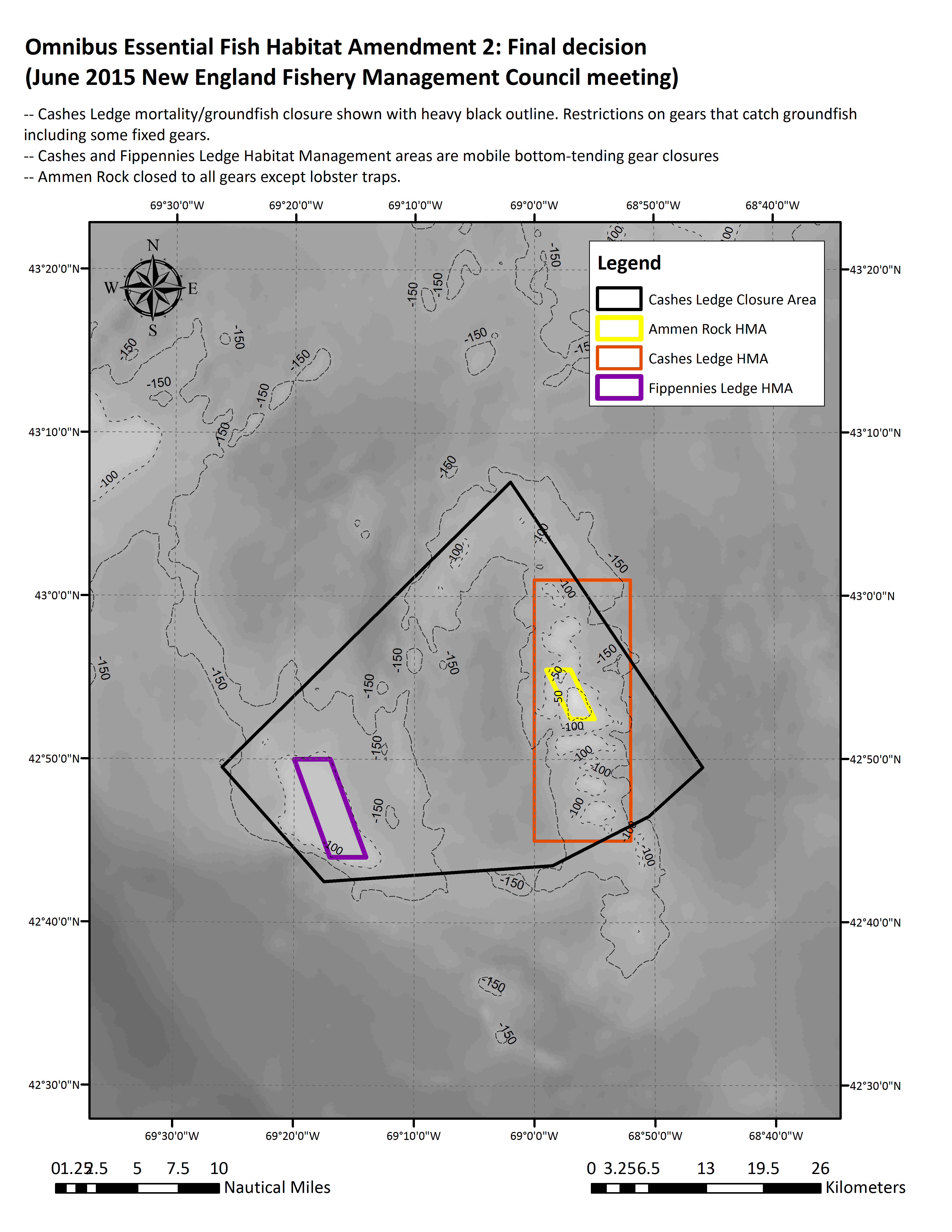
WASHINGTON (Saving Seafood) – September 1, 2015 — Fishermen, fisheries managers, and environmentalists agree that the Cashes Ledge region of the Gulf of Maine is home to some of the most important marine environments in New England. These include lush kelp forests and the diverse ecosystem of Ammen Rock. Since the early 2000s, federal fisheries managers have recognized the value of these areas and have taken proactive steps to protect their unique habitats, preventing commercial fishermen from entering the areas and allowing them to develop mostly undisturbed from human activity.

But according to several environmental groups, including the Conservation Law Foundation, Pew Charitable Trusts, the National Geographic Society, and the Natural Resources Defense Council, such long-standing and effective protections are suddenly insufficient. A public relations, media and lobbying campaign has launched to have Cashes Ledge and the New England Canyons and Seamounts designated a National Monument. While such an effort may seem consistent with the current record of environmental stewardship on Cashes Ledge, such a designation would actually undermine the current management system by removing local and expert input from the process.

The current closures on Cashes Ledge are the result of an open, democratic and collaborative process. Managed by the New England Fishery Management Council (NEFMC), the protections are the result of extensive consultation with scientists, fishermen, regulators, and other valuable stakeholders in New England. Through this process, the Council built a durable consensus in the region on the need to protect and preserve Cashes Ledge. As a result, no federally managed fisheries are allowed to operate in the area. Only the state-managed lobster fishery is permitted in the region, which is subject to the equally open and public management process of the Atlantic States Marine Fisheries Commission (ASMFC).

This process has been successful in making Cashes Ledge the hotspot for marine life that it is today. In fact, it has done everything that we usually ask of successful habitat management. The area has been closed for over a decade, and there are no plans to open it in the future. The bottom-tending gear that is likely to disturb habitats is already prohibited in this area. In the recently passed Omnibus Habitat Amendment 2 (OHA2), the Cashes Ledge closures remain untouched, and the current levels of protection are extended into the foreseeable future.

Since 2012, the NEFMC has been working on extending similar protections to the corals and other habitat features of the New England Canyons and Seamounts. Combined with efforts such as NOAA’s Deep-Sea Coral Data Portal, the Council is collaborating with a variety of stakeholders to fashion the best possible protections for the area. On September 23, the Council’s Habitat Committee will be discussing the Omnibus Deep-Sea Coral Amendment. Much like with the habitat protections on Cashes Ledge, this is being conducted through an open and public process that includes scientists, fishermen, regulators, and other interested parties.

So while CLF press secretary Josh Block has been recently quoted as saying a National Monument designation would ensure that the area “remains permanently protected from harmful commercial extraction, such as oil and gas drilling, commercial fishing and other resource exploration activities,” there are no actual attempts to remove the current protections, or to allow any of these activities on Cashes Ledge. Monica Medina of the National Geographic Society, who served in the Obama Administration as Principal Deputy Undersecretary for Oceans and Atmosphere at NOAA, acknowledges that the areas “are currently closed to industrial fishing,” but goes on to say “there have been calls to open them to fishing at some point in the future.” From who is a mystery, because during the OHA2 process, the only suggested openings were for scientific analysis.

National Geographic’s Monica Medina wrote, “scientists have recently uncovered some offshore treasures [in New England]: an area called Cashes Ledge, plus five canyons and sea mounts.” In fact, Cashes Ledge was mapped by R. Rathbun and J. W. Collins in 1887. National Geographic Explorer-in-Residence Dr. Sylvia Earle herself acknowledged this after a recent dive, stating, “I saw for myself what scientists have been raving about for years.” And in what turned out to be a harbinger of the National Monument effort, Dr. Earle stated, “Cashes Ledge is the Yellowstone of the North Atlantic.”

In addition to being superfluous to the effective management of Cashes Ledge, a National Monument designation would undermine the management system already in place. A designation of a National Monument necessitates unilateral action by the President under the 1906 Antiquities Act. Such action circumvents and strips away valuable democratic processes that protect these regions and sustain their important commercial fisheries. The council system by which areas like Cashes Ledge are managed – and through which such areas are already off limits to most fishermen – would diminish in importance, as would the expert input from all relevant stakeholders, including scientists, fishermen, and conservationists.

The current management structures and systems now in place under federal guidelines, including the management of the NEMFC and ASMFC, and other regulatory procedures – including proposals to change protections – are fundamentally democratic. They allow ample time for stakeholder input from all perspectives. If organizations such as CLF and the Pew Charitable Trusts want to alter current habitat protections, there is a decades-old, established public process to accommodate them.

These procedures have led to remarkable recent success stories. In fact, just two months ago, both CLF and Pew Charitable Trusts praised the very procedures they now seek to circumvent. In June, the Mid-Atlantic Fishery Management Council voted to protect 38,000 square miles of marine habitat to preserve deep-sea corals. The same council process that produced such laudable results in the Mid-Atlantic is the same one that is in place New England. A unilateral marine monument designation, in contrast, would nullify existing management.

Recent history also demonstrates the risks and pitfalls of unilateral attempts to designate marine National Monuments of the exact sort as that being proposed for Cashes Ledge. The expansion of the Pacific Remote Islands Marine National Monument by President Obama in 2014, for example, came under intense public scrutiny from native Pacific Islanders, commercial fishermen, and scientists alike, all of whom criticized the Administration for failing to consider crucial stakeholder input.

The current proposal for a National Monument on Cashes Ledge is a solution in search of a problem. It fixes a process that isn’t broken. It seeks an outcome that is already in effect. And it removes the public from the management of public resources.

June 2015 Cashes Ledge final


  • « Previous Page
  • 1
  • 2
  • 3

Recent Headlines

  • NEW JERSEY: Recreational fishermen will hate this: Regulators want more spiny dogfish in the water
  • MAC: EU’s Ukraine war response requires more top-level fisheries, aquaculture action
  • ALASKA: Climate change takes back seat in Alaska’s bycatch showdown
  • Revolution Wind Turbines’ Effects on Life in the Sea and on the Seafloor Remain Unclear
  • NEFMC Recommends 2023 Recreational Cod and Haddock Measures; Revises Halibut ABC in Framework 65
  • The United States must act to stop illegal fishing in 2023
  • Despite a pause on new regulations, U.S. and Canadian lobstermen see big challenges ahead
  • Legal sizes for lobsters could change to protect population

Most Popular Topics

Alaska Aquaculture ASMFC Atlantic States Marine Fisheries Commission BOEM California Climate change Coronavirus COVID-19 Donald Trump groundfish Gulf of Maine Gulf of Mexico Illegal fishing IUU fishing Lobster Maine Massachusetts Mid-Atlantic National Marine Fisheries Service National Oceanic and Atmospheric Administration NEFMC New Bedford New England New England Fishery Management Council New Jersey New York NMFS NOAA NOAA Fisheries North Atlantic right whales North Carolina North Pacific offshore energy Offshore wind Pacific right whales Salmon Scallops South Atlantic Tuna Western Pacific Whales wind energy Wind Farms

Daily Updates & Alerts

Enter your email address to receive daily updates and alerts:
  • This field is for validation purposes and should be left unchanged.
Tweets by @savingseafood

Copyright © 2023 Saving Seafood · WordPress Web Design by Jessee Productions