Saving Seafood

  • Home
  • News
    • Alerts
    • Conservation & Environment
    • Council Actions
    • Economic Impact
    • Enforcement
    • International & Trade
    • Law
    • Management & Regulation
    • Regulations
    • Nutrition
    • Opinion
    • Other News
    • Safety
    • Science
    • State and Local
  • News by Region
    • New England
    • Mid-Atlantic
    • South Atlantic
    • Gulf of Mexico
    • Pacific
    • North Pacific
    • Western Pacific
  • About
    • Contact Us
    • Fishing Terms Glossary

Hawaii Prepares Plan to Help Coral Recover From Bleaching

September 9, 2016 — KANEOHE, Hawaii — Hawaii officials proposed a series of steps to fight coral bleaching that’s threatening the state’s reefs, including new marine protected areas, limits on fishing and controlling polluted runoff from land.

Hawaii’s ocean temperatures have been rising as greenhouse gases in the atmosphere have increased, forcing corals to expel algae they rely on for food. Vast stretches of reef have turned white over the past two summers, increasing the risk that the coral will get sick and die. Some already have died.

It’s a serious concern for the health of the ocean because coral reefs provide habitat for fish and other marine life, scientists say. Severe or concurrent years of bleaching can kill coral reefs, as has been documented over the past two years in oceans around the world. Scientists expect a third year of bleaching to last through the end of 2016.

Bruce Anderson, the state Division of Aquatic Resources administrator, said addressing polluted runoff is difficult, noting it would cost millions of dollars to create artificial wetlands that would help control runoff. Fishermen in the past have also resisted moves to limit their catch.

But Anderson said the coral bleaching crisis presents an opportunity.

“We are going to have future bleaching events, and the water is going to get warmer. And it’s going to happen again and again,” he said Thursday. “So our challenge is to prevent the impacts of bleaching as much as we can and also to help the reefs recover.”

Read the full story from the Associated Press at ABC News

NOAA Announces Proposals to Expand Flower Garden Banks National Marine Sanctuary

June 9, 2016 — Building on more than 30 years of scientific studies, including numerous reports released in the last decade and in the aftermath of the 2010 Deepwater Horizon oil spill disaster, NOAA today announced a proposal to expand Flower Garden Banks National Marine Sanctuary to protect additional critical Gulf of Mexico habitat.

The plan lays out five expansion scenarios, ranging from no expansion of the 56-square-mile sanctuary, to one bringing it to a total of 935 square miles. In NOAA’s preferred scenario, the sanctuary would expand to 383 square miles to include 15 reefs and banks that provide habitat for recreationally and commercially important fish, as well as a home to 15 threatened or endangered species of whales, sea turtles, and corals.

“These habitats are the engines of sustainability for much of the Gulf of Mexico and are critical to fish such as red snapper, mackerel, grouper and wahoo, as well as other protected species,” said John Armor, acting director, NOAA’s Office of National Marine Sanctuaries. “The proposed expansion also advances NOAA’s mission to conserve and manage coastal and marine ecosystems and resources that help sustain local communities and America’s economy.”

Read the full story at Ocean News

Considering Pacific marine monument expansion

May 9, 2016 — HONOLULU — A Native Hawaiian proposal that calls for the expansion of the Papahanaumokuakea Marine National Monument is picking up steam and this week a delegation from the Obama Administration is meeting with stakeholders to discuss the possibility.

The waters around Kauai and Niihau, however, would be exempt from the expansion, according to news release sent to The Garden Island on Thursday.

“As Native Hawaiians, our core identity and survival is tied to the ocean. The Northwestern Hawaiian Islands is where we believe life originated,” said Kekuewa Kikiloi, Chair, Northwestern Hawaiian Islands Native Hawaiian Cultural Working Group. “All resources in nature – from corals to sharks – have cultural significance for Native Hawaiians and are an embodiment of our ancestors. By expanding Papahanaumokuakea we can help protect our cultural ocean-scapes and show future generations that preservation of the environment is preservation of our cultural traditions.”

Read the full story at the Garden Island

Rising Carbon Dioxide Levels Threaten Corals and Oysters

April 5, 2016 — Tiny, thin-shelled oysters; crumbling coral reefs; fish unable to make sense of odors; decimated plankton populations. Those are some of the nightmare scenarios conjured by the prospect of a rapidly acidifying ocean caused by unchecked carbon dioxide emissions from fossil fuel burning.

Here’s the chemistry: when carbon dioxide and water mix, they form a weak acid, called carbonic acid. Add enough carbon dioxide, and the pH, or acidity, of the water will start to change. Of course, the ocean is a big place with a lot of water, and it naturally contains other chemicals that can help stabilize the pH.

On the other hand, the ocean has absorbed more than a quarter of all human-produced carbon dioxide since the industrial revolution. The result: globally, the pH of the ocean has dropped by an average of 0.1 pH units. That may not sound like much but, since the pH scale is logarithmic, it translates to a 25 to 30 percent increase in acidity. And, as ocean water becomes more acidic, the carbonate that many animals use to build their calcium skeletons and shells becomes scarcer.

Read and listen to the full story at WCAI

PETER BAKER: We Must Do More to Save Deep-Sea Corals

Editor’s Note: While Peter Baker’s commentary notes that New England fishery managers “have not yet put forward a plan for protection” of New England’s deep-sea corals, the New England Fishery Management Council (NEFMC) has in fact been working since 2012 to extend protections to the region’s coral habitats. The Council’s effort, the Omnibus Deep-Sea Coral Amendment, is still in development, but contains protections similar to the much-lauded coral protections enacted by the Mid-Atlantic Fishery Management Council through their own Deep Sea Corals Amendment.

December 8, 2015 — Less than 100 miles offshore from the heavily populated Eastern Seaboard lie submerged seascapes that look more like visions from another world than the cities and landmarks for which they are named.

Baltimore Canyon, Norfolk Canyon, Hudson Canyon, and others were carved by ancient rivers back when seas were shallow and the coastline was radically different. Now, these undersea canyons gouge into the edge of the continental shelf, plunging thousands of feet seaward to the abyss.

Scientists, exploring these places with robotic submersibles, have upended our assumptions about the deep sea. Far from a barren seafloor, these canyons teem with life—from familiar fish, squid, and crabs to some animals so bizarre that they could easily pass for creatures in a sci-fi flick. Some of the stranger sightings here include gangly crustaceans called sea spiders; the long-nosed chimera, or ghost shark; and the comical “Dumbo” octopus, which propels itself with earlike protrusions.

Most amazing, perhaps, are the living structures known as deep-sea corals that many of these animals depend upon for habitat. Unlike the familiar corals of the warm, shallow waters, these corals are adapted to the cold, dark depths where they slowly grow. Colorful bubblegum corals form bulbous ends in bright pinks, while fan corals grow in veined sheets of maroon and brown. Many deep-sea corals are centuries old, and some are among the Earth’s oldest known living animals.

Read the full commentary at the Pew Charitable Trusts


NOAA Seeking Input on deep sea canyon and seamount protection

September 16, 2015 — The following was released by NOAA:

NOAA invites your input on possible permanent protections for three deep sea canyons — Oceanographer, Gilbert, and Lydonia — and four seamounts off of New England’s coast. Deep sea canyons, which plunge to depths greater than 7,000 feet, and sea mounts, which rise thousands of feet above the sea floor, create unique habitats supporting tremendous biodiversity and fragile ecosystems that are home to corals, fish, marine mammals, turtles, and more.

To ensure that we protect these unique places for future generations while recognizing the importance of sustainable ocean-based economies, we are seeking input from all interested parties in the region. 

Please send comments as soon as possible to atlanticconservation@noaa.gov 

Questions? Contact Allison Ferreira, Regional Office, at 978-281-9103 or Allison.Ferreira@noaa.gov

Credit: NOAA


Marine Matters: Beauty Beneath the Sea

September 2, 2015 — Most people when they hear the word “coral” think of shallow, turquoise water and colorful reefs populated by bright tropical fish. Now think again. In the cold and often dark Gulf of Maine, spectacular cold-water coral formations, some of which may be hundreds if not thousands of years old, are just now being mapped and explored.

Most cold-water corals lie in the very deep submarine canyons and seamounts along the edge of the continental shelf. Yet they also occur in deep areas of the Gulf that are closer to shore, such as Jordan Basin. Cold-water corals typically are soft corals with flexible skeletons, unlike the coral species that build tropical reefs. Fishermen have long been familiar with taller coral outcroppings, which they called “trees,” on Georges Bank and other shallow-water areas in the Gulf.

Since 2013 scientists funded through NOAA’s Deep Sea Coral Research and Technology Program have been conducting research cruises in the Gulf of Maine using remotely controlled underwater vehicles and multibeam sonar to identify cold-water coral communities. This year during a ten-day research cruise, scientists from the University of Maine, the Northeast Fisheries Science Center, and the Northeast Underwater Research, Technology and Education Center at the University of Connecticut looked at three areas: Outer Schoodic Ridge, the Mount Desert Rock area and the Georges Basin region.

Read the full story at The Free Press

Saving Seafood Analysis: Campaign for New England Marine Monument a “Solution in Search of a Problem”

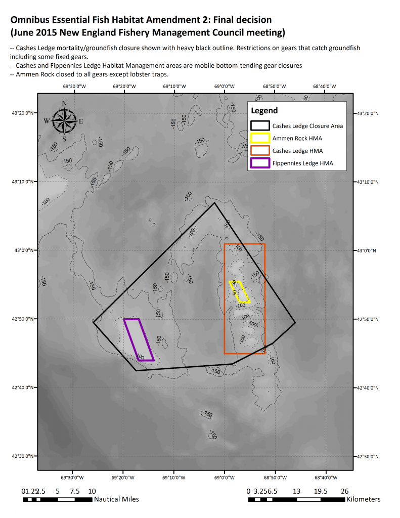
WASHINGTON (Saving Seafood) — September 1, 2015 — An analysis released today by Saving Seafood examines a proposal from several environmental organizations to extend “permanent” protections to the Cashes Ledge region of the Gulf of Maine and the New England Canyons and Seamounts, by asking President Obama to declare the area a National Monument. The analysis notes that these efforts are largely duplicative of area closures already in place in this region, none of which are poised for opening. Saving Seafood further concludes that such a unilateral move would undermine the democratic and collaborative processes that to date have been highly effective in preserving and protecting the area.

Read the analysis from Saving Seafood here

The Conservation Law Foundation (CLF) and partners including the National Geographic Society, Pew Charitable Trusts and the Natural Resources Defense Council intend to ask that these areas be declared the eastern seaboard’s first Marine National Monument, according to emails sent by CLF to State House News Service. A sold out event scheduled for Wednesday, September 2 at the New England Aquarium, featuring National Geographic and the CLF, is expected to discuss this proposal. Last Friday, Maine Governor Paul LePage wrote to President Obama opposing the designation of areas within the Gulf of Maine as a national maritime monument, as reported by the Portland Press Herald.

Such a designation would be both duplicative of, and possibly damaging to, the current management of Cashes Ledge, according to the Saving Seafood analysis. Closures already in place, developed through an open, democratic and collaborative process under the Magnuson-Stevens Act, already prohibit fishing of federally managed species in the area. These prohibitions have been in place for over a decade, the analysis notes, and have been extended into the foreseeable future with the recent passage of Omnibus Habitat Amendment 2. The Council is actively working on extending similar protections to the New England Canyons through the Deep-Sea Coral Amendment.

A petition being circulated by CLF and promoted by National Geographic notes that a “trawl could strip clear the kelp forest on Ammen Rock,” but as noted in the Saving Seafood analysis, current protections for these areas – including regulations passed as recently as June of this year – already protect areas such as Ammen Rock and the kelp forests. Saving Seafood notes that none of these areas are being considered for opening to fishing.

The Saving Seafood report also cautions against proposals to create “permanent” protections for these areas that would circumvent the process already in place to manage New England’s marine habitats. It notes that the New England Fishery Management Council has responsibility for managing Cashes Ledge and other habitat areas. Through a deliberative, consultative effort involving input from scientists, public officials, regulators, and other stakeholders, the Council has consistently protected the unique habitats on both Cashes Ledge and other areas in the Gulf of Maine and Georges Bank.

According to the analysis, efforts to circumvent these procedures in pursuit of ostensibly “permanent” protections, such as a National Monument designation via the Antiquities Act, would undermine the open and democratic management process that has already resulted in the long-term protection of Cashes Ledge. Upending the regulatory process that has worked so well for so long is likely to do more harm than good, the report concludes.

June 2015 Cashes Ledge final


Read the analysis from Saving Seafood here


Reef protections aim to grow fish stocks

July 28, 2015 — Fishing practices that disturb the sea floor will soon be banned in a 38,000-square mile swath of the Atlantic Ocean in an effort to protect fragile East Coast coral reefs.

While the new rules will mean fishermen are catching less in coral zones, officials say the effort could grow fish populations, keeping customers from having to pay more for seafood.

In mid-June, the Mid-Atlantic Fishery Management Council voted to establish “deep sea coral zones” from waters off the northern North Carolina border through New York. Trawls, dredges, bottom long lines and traps would be prohibited in the protected area, which starts at about the 450-feet depth point and extends 200 miles out to sea.

The rule still needs to be approved by the U.S. Secretary of Commerce, but it would complement protections passed in 2010 by sister organization the South Atlantic Fishery Management Council to safeguard coral zones from Southeastern North Carolina through Florida.

Read the full story at Star News Online

NOAA Fisheries Announces Final Rule to Expand Boundaries of Habitat Areas of Particular Concern and to Modify Transit Provisions

July 17, 2015 — The following was released by NOAA:

On July 17, 2015, NOAA Fisheries published a final rule (80 FR 42423) to implement Amendment 8 to the Fishery Management Plan for Coral, Coral Reefs, and Live/Hardbottom Habitats of the South Atlantic Region (Coral Amendment 8). Regulations will be effective on August 17, 2015.

The amendment extends protections for deepwater coral ecosystems by expanding the boundaries of the Oculina Bank Habitat Area of Particular Concern, and the Stetson-Miami Terrace and Cape Lookout Coral Habitat Areas of Particular Concern.

Within Habitat Areas of Particular Concern, the use of bottom longline, bottom trawl, dredge, pot or trap is prohibited. If aboard a fishing vessel, anchor, use of anchor and chain, and grapple and chain is prohibited. Mid-water trawls are also prohibited in Stetson-Miami Terrace and Cape Lookout Coral Habitat Areas of Particular Concern.

Coral Amendment 8 also implements a transit provision through Oculina Bank Habitat Area of Particular Concern for fishing vessels with rock shrimp onboard. When traveling through the area, vessels are required to have gear appropriately stowed and maintain a minimum speed of five knots. Vessel speed is determined by a vessel monitoring system registering a ping (signal) at a rate of 1 ping per 5 minutes.

More Information

For more information on Coral Amendment 8, please click on this link to the Frequently Asked Questions found at:

http://sero.nmfs.noaa.gov/sustainable_fisheries/s_atl/coral/2014/am8/index.html.

Maps of the revised Coral Habitat Areas of Particular Concern can be found on our website at:

http://sero.nmfs.noaa.gov/maps_gis_data/fisheries/s_atlantic/index.html. 

This bulletin serves as a Small Entity Compliance Guide, complying with section 212 of the Small Business Regulatory Enforcement Fairness Act of 1996.

This bulletin provides only a summary of the information regarding the existing regulations. Any discrepancies between this bulletin and the regulations as published in the Federal Register will be resolved in favor of the Federal Register.

Consider signing up for fishery bulletins via email.

To receive fishery bulletins electronically, via email, you must sign up through Constant Contact. Constant Contact is an internet-based distribution service. This service allows you to subscribe or unsubscribe at any time. The electronic copy of the bulletin will be delivered to you faster than the paper copy, is in color, features informational links, and reduces paper use.

To receive fishery bulletins via email using Constant Contact, please sign up at http://bit.ly/HQDUEU. You may also sign up for Constant Contact by visiting our Web site http://sero.nmfs.noaa.gov (sign-up option is located on the left side of the page).


  • « Previous Page
  • 1
  • 2
  • 3
  • Next Page »

Recent Headlines

  • A data-driven model to help avoid ecosystem collapse
  • Trump reverses course on salmon restoration in the Pacific Northwest
  • CALIFORNIA: California removes limits on sardine fishing after domoic acid concerns pass
  • Researchers make alarming discovery after analyzing stomach of deep-sea fish that washed ashore on US coast: ‘They are not picky eaters’
  • Keeping a labor force in the pipeline
  • At U.N. Conference, Countries Inch Toward Ocean Protection Goal
  • CALIFRONIA: California to shutter last open Dungeness crab fishing zones
  • Responsible Fishery Management is a Powerful Tool to Conserve Our Ocean

Most Popular Topics

Alaska Aquaculture ASMFC Atlantic States Marine Fisheries Commission BOEM California China Climate change Coronavirus COVID-19 Donald Trump groundfish Gulf of Maine Gulf of Mexico Hawaii Illegal fishing IUU fishing Lobster Maine Massachusetts Mid-Atlantic National Marine Fisheries Service National Oceanic and Atmospheric Administration NEFMC New Bedford New England New England Fishery Management Council New Jersey New York NMFS NOAA NOAA Fisheries North Atlantic right whales North Carolina North Pacific offshore energy Offshore wind Pacific right whales Salmon South Atlantic Western Pacific Whales wind energy Wind Farms

Daily Updates & Alerts

Enter your email address to receive daily updates and alerts:
  • This field is for validation purposes and should be left unchanged.
Tweets by @savingseafood

Copyright © 2025 Saving Seafood · WordPress Web Design by Jessee Productions