Saving Seafood

  • Home
  • News
    • Alerts
    • Conservation & Environment
    • Council Actions
    • Economic Impact
    • Enforcement
    • International & Trade
    • Law
    • Management & Regulation
    • Regulations
    • Nutrition
    • Opinion
    • Other News
    • Safety
    • Science
    • State and Local
  • News by Region
    • New England
    • Mid-Atlantic
    • South Atlantic
    • Gulf of Mexico
    • Pacific
    • North Pacific
    • Western Pacific
  • About
    • Contact Us
    • Fishing Terms Glossary

Northeast Seafood Coalition responds to erroneous statements on Cashes Ledge from Pew Charitable Trusts

The following was released by the Northeast Seafood Coalition:

March 29, 2016 – GLOUCESTER, Mass. – Earlier today, in a webinar releasing a new report regarding the environmental composition of Cashes Ledge, in response to Cape Cod Times reporter Doug Fraser’s question as to whether there is an imminent threat to Cashes Ledge, The Pew Charitable Trusts’ Director of US Oceans, Northeast, Peter Baker stated:

“..the different areas – Cashes Ledge, the coral canyons, and the sea mounts – have different pressures on them, and different levels of imminent pressures that might be put on them. For instance Cashes Ledge, some of the council members, led by Terry Alexander, who is the president of the Associated Fisheries of Maine and was quoted in a press release last week, put up a motion just last year at the NEFMC to open Cashes Ledge once again to bottom trawling. The other guy, Vito Giacalone, who was quoted in that press release, at a public forum in Gloucester just last month, said that the fishing industry is eager to get in and catch the cod that are in Cashes Ledge. So, certainly the leaders of the groundfish industry have made it clear, recently, that they’re eager and working to get back in there and that at every available opportunity they’re going to try and open up Cashes to bottom trawling again. So I’d say, yes, absolutely, there’s an imminent threat to Cashes Ledge.”

The statement attributed to Vito Giacalone of the Northeast Seafood Coalition, and the description of the motion made by Councilmember Terry Alexander are factually inaccurate. There was never a motion or statement made proposing access to Cashes Ledge.

The problem is the terminology used.  “Cashes Ledge” is often used as verbal shorthand to refer to the large, 1400 square kilometer ‘Mortality Closure’ that includes Cashes Ledge and the surrounding areas and is an artifact of the old effort control system created to protect cod.

What we did say, and will maintain, is that once the old effort control system was replaced with a quota system, we want to be able to access the old mortality closures, including the Cashes Ledge Mortality Closure when such access is appropriate and scientifically justified. These portions of the Cashes Ledge Mortality Closure, despite the name, are not located on Cashes Ledge.

The Northeast Seafood Coalition proposed and supports the habitat management areas developed with government science, included in Omnibus Habitat Amendment 2 which was adopted by the New England Fisheries Management Council last June, and are pending approval by NOAA.

We collaborated with the Associated Fisheries of Maine, and with the Fisheries Survival Fund, representing the limited access scallop fleet.  We did not develop our own habitat closed area on Cashes Ledge, but rather embraced the habitat management area developed via the government science.

This habitat area is significantly larger than Cashes Ledge itself, in fact, it completely engulfs Cashes Ledge, all of the kelp forest, and all of the areas displayed in the video and photographs circulated in recent months by proponents of a marine national monument. The protected area includes a surrounding buffer of hundreds of square miles.

We never would propose re-entering an area which we agreed to protect, and especially this area that encompasses Cashes Ledge.  It is simply untrue to say that we stated that we are “eager” to fish within the habitat management area on Cashes Ledge.

Did we say we want to preserve the ability to access portions of the mortality closure such as Cashes Basin and other basins that were not identified as important habitat areas by the science? Yes, we did say that.

We have no way of knowing whether Mr. Baker’s statement was made to intentionally mislead, or simply out of a lack of clear understanding regarding the difference between Cashes Ledge, the habitat management area surrounding Cashes Ledge, and the remaining portions of the previous mortality areas that were artifacts of the old system, but we state unequivocally that it is not true to say we ever proposed accessing the Cashes Ledge habitat management area.

Environmental groups release scientific analysis of areas proposed for Atlantic marine monuments

March 29, 2016 – WASHINGTON (Saving Seafood) – This morning, the “Protect New England’s Ocean Treasures Coalition” released an analysis of Northeast ocean areas under consideration for designation as marine National Monuments. The analysis was conducted by Dr. Peter Auster of Mystic Aquarium and Dr. Scott Kraus of the New England Aquarium, and was presented in a press webinar organized by the Pew Charitable Trusts.

Dr. Auster and Dr. Kraus concluded, among other findings, that the proposed monument areas possess high habitat diversity and an abundance of species, function as a source of habitats including for commercial species, and contain species sensitive to disturbance. However, they noted that they do not have adequate data to address what the economic and human effects of area closures to fisheries might be. Presenters also acknowledged that the areas under consideration are already protected, but expressed concern about the future possibility of drilling and mining.

A monument designation would likely affect the fisheries for Atlantic red crab, offshore lobster, squid, mackerel, butterfish, tilefish, albacore wahoo, dolphinfish (mahi mahi), and others. Pelagic longline, rod and reel, and greenstick fisheries including yellowfin tuna, bluefin tuna, bigeye tuna, and swordfish may also be affected. During the webinar, the presenters conceded that they do not have enough data to analyze how a monument designation would affect many of these fisheries.

The analysis addressed both Cashes Ledge and the Northeast Seamounts and Canyons. White House officials stated last week that Cashes Ledge is “not under consideration for a [national monument] designation at this time.” However, representatives of the Northeast Seafood Coalition and Associated Fisheries of Maine, who attended meetings with White House officials, said in a joint statement that offshore canyon areas east of Cape Cod remain under consideration and “affected fishermen should remain vigilant in assuring that any concerns they may have are addressed.”

The Protect New England’s Ocean Treasures Coalition, which “is advocating for the establishment of a Marine National Monument in the North Atlantic Ocean,” is composed of:

  • Center for American Progress
  • Conservation Law Foundation
  • Environment America
  • Mystic Aquarium
  • National Geographic Society
  • National Wildlife Federation
  • Natural Resources Defense Council
  • New England Aquarium
  • Ocean Conservancy
  • Oceana
  • The Pew Charitable Trusts

Read a fact sheet about the proposed Atlantic monument areas

Captions courtesy of Pew Charitable Trusts

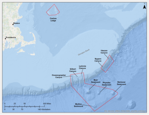
Proposed NE monument

Proposed Marine National Monument in Northeastern Waters of the U.S.

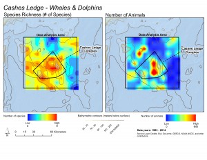
These maps illustrate that while whale and dolphin species are distributed throughout the whole Cashes Ledge region, the deep water toward the center of the proposed monument area is a hot spot for both the total numbers of species (left) and the total numbers of animals (right). Courtesy of Scott Kraus and Brooke Wikgren, New England Aquarium

These maps illustrate that while whale and dolphin species are distributed throughout the whole Cashes Ledge region, the deep water toward the center of the proposed monument area is a hot spot for both the total numbers of species (left) and the total numbers of animals (right). Courtesy of Scott Kraus and Brooke Wikgren, New England Aquarium

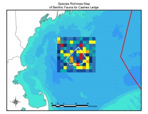
This map illustrates the pattern of species richness (number of species) of bottom-dwelling animals in the Cashes Ledge area. Warmer colors indicate more species. The largest red diversity hot spot is the peak of Cashes Ledge, where the largest continuous kelp forest on Cashes Ledge is located. Note that this map displays number of species, not numbers of individuals or density of animals. Courtesy of Peter Auster and Michel McKee, Mystic Aquarium

This map illustrates the pattern of species richness (number of species) of bottom-dwelling animals in the Cashes Ledge area. Warmer colors indicate more species. The largest red diversity hot spot is the peak of Cashes Ledge, where the largest continuous kelp forest on Cashes Ledge is located. Note that this map displays number of species, not numbers of individuals or density of animals. Courtesy of Peter Auster and Michel McKee, Mystic Aquarium

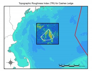
Topographic roughness – essentially, small-scale bumpiness of the seafloor – is linked to the distribution and diversity of microhabitats that in turn support a diversity of species. Warmer colors indicate greater "roughness" and are linked to locations of species-rich communities. For example, the area of high roughness on the top of Cashes Ledge (right inside the proposed monument boundary) is where the kelp forest is located and a species diversity hotspot. Courtesy of Peter Auster and Michel McKee, Mystic Aquarium

Topographic roughness – essentially, small-scale bumpiness of the seafloor – is linked to the distribution and diversity of microhabitats that in turn support a diversity of species. Warmer colors indicate greater “roughness” and are linked to locations of species-rich communities. For example, the area of high roughness on the top of Cashes Ledge (right inside the proposed monument boundary) is where the kelp forest is located and a species diversity hotspot. Courtesy of Peter Auster and Michel McKee, Mystic Aquarium

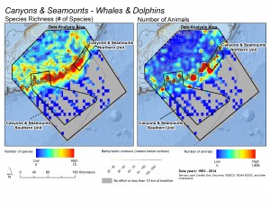
These maps illustrate patterns in the richness of species (left) and total numbers of whales and dolphins (right) observed during surveys in the Northeast Canyons and Seamounts region. Warmer colors indicate greater richness or abundance. Note how species concentrate on the eastern Georges Bank, where the shelf descends into the deep ocean, and hot spots for concentrations of whales and dolphins dot the shelf-edge. Courtesy of Scott Kraus and Brooke Wikgren, New England Aquarium

These maps illustrate patterns in the richness of species (left) and total numbers of whales and dolphins (right) observed during surveys in the Northeast Canyons and Seamounts region. Warmer colors indicate greater richness or abundance. Note how species concentrate on the eastern Georges Bank, where the shelf descends into the deep ocean, and hot spots for concentrations of whales and dolphins dot the shelf-edge. Courtesy of Scott Kraus and Brooke Wikgren, New England Aquarium

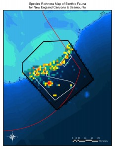
This map shows hot and cold spots for species of bottom-dwelling animals in the New England Canyons and Seamounts areas. Species are especially diverse along the edge of Georges Bank, where the shelf descends into the deep ocean. Hot spots are also visible on Bear, Physalia, Retriever and Mytilus Seamounts. Courtesy of Peter Auster and Michel McKee, Mystic Aquarium

This map shows hot and cold spots for species of bottom-dwelling animals in the New England Canyons and Seamounts areas. Species are especially diverse along the edge of Georges Bank, where the shelf descends into the deep ocean. Hot spots are also visible on Bear, Physalia, Retriever and Mytilus Seamounts. Courtesy of Peter Auster and Michel McKee, Mystic Aquarium

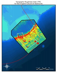
Topographic roughness – essentially small-scale bumpiness of the seafloor – is linked to the distribution and diversity of microhabitats that in turn support a diversity of species. Warmer colors indicate greater "roughness" and are linked to locations of species-rich communities. A high topographic roughness value suggests where especially rich communities may be found. The entire shelf-edge, where Georges Bank descends into the deep ocean, is topographically rough, and Bear, Physalia, Retriever and Mytilus Seamounts stand out. Courtesy of Peter Auster and Michel McKee, Mystic Aquarium

Topographic roughness – essentially small-scale bumpiness of the seafloor – is linked to the distribution and diversity of microhabitats that in turn support a diversity of species. Warmer colors indicate greater “roughness” and are linked to locations of species-rich communities. A high topographic roughness value suggests where especially rich communities may be found. The entire shelf-edge, where Georges Bank descends into the deep ocean, is topographically rough, and Bear, Physalia, Retriever and Mytilus Seamounts stand out. Courtesy of Peter Auster and Michel McKee, Mystic Aquarium

SALEM NEWS: Cashes Ledge decision a victory for open government

March 29, 2016 — The decision by the Obama administration to pass on a proposal to make a large swath of the Gulf of Maine a national monument is not only a victory for fishermen. It’s also a win for those who favor open government.

News came late last week that the administration would not, in fact, use the federal Antiquities Act to make the the area around Cashes Ledge a permanent “maritime national monument” by executive decree.

Such status is set aside for for areas of outstanding scientific, cultural, conservation and aesthetic value. President George W. Bush established four and Obama expanded one, the Pacific Remote Islands Marine National Monument, according to the Associated Press.

Cashes Ledge, about 80 miles off the coast of Cape Ann, provides a habitat to sharks, dolphins and sea turtles and migrating, endangered North Atlantic right whales.

The area, more than 520 square nautical miles, is certainly worth protecting. However, there are already rules in place doing just that. The area is currently off limits to fishing, and there are no plans for that to change.

Read the rest of the column at The Salem News

President Obama Will Not Designate Cashes Ledge as a National Monument

WASHINGTON (Saving Seafood) — March 25, 2016 — Earlier today, a spokesperson for the White House Council on Environmental Quality told the Associated Press that Cashes Ledge is “not under consideration for a [national monument] designation at this time.” According to attendees at meetings held yesterday in Massachusetts, Christy Goldfuss, Managing Director at the White House Council on Environmental Quality, stated, “Based on feedback we received, we are not considering Cashes Ledge for any kind of action at this time.” Located approximately 80 miles offshore in the Gulf of Maine, Cashes serves an important and historic area that has been fished commercially and recreationally for decades.

The Northeast Seafood Coalition and Associated Fisheries of Maine noted in a joint statement that, “Consideration of National Monument designations in the offshore Canyon areas of Southern New England remains ongoing, and affected fishermen should remain vigilant in assuring that any concerns they may have are addressed.”  Fishing interests including the Atlantic red crab fishery, offshore lobster fishery, squid, mackerel, butterfish, tilefish, albacore wahoo,dolphinfish (mahi mahi), and others have interests in areas that remain on the table. Pelagic longline, rod and reel and greenstick fisheries including yellowfin tuna, bluefin tuna, bigeye tuna and swordfish could also be affected.

The New England Fishery Management Council (NEFMC) is in the midst of an ongoing process working with fishing, environmental and scientific interests to protect deep sea coral and other important sea bottom attributes in the Northeast Canyons. NEFMC executive director Tom Nies told Saving Seafood, “The Council’s recommendations to protect Cashes Ledge are still being reviewed as part of our Omnibus Habitat Amendment. The Council has not taken a position on any of the monument proposals that have been circulated, but the meeting in Boston did give us the opportunity to explain our deep-sea coral amendment process directly to Ms. Goldfuss. We are very pleased that CEQ traveled to New England to give us this opportunity. I think the industry and state representatives present also appreciated this face-to-face meeting and we all look forward to a continuing dialogue.”

In response to the announcement, Terry Alexander, President, Associated Fisheries of Maine said, “Commercial fishermen in New England face continuous regulatory uncertainty, so it is a relief to know that there is one less restriction on fishing to worry about. We believe that the President was persuaded by a lack of scientific information to support such a designation, as well as the position expressed by stakeholders that decisions about closing areas to fishing should take place under the process outlined in the Magnuson Stevens Fishery Conservation and Management Act (MSA).”

Vito Giacalone, Chair of Governmental Affairs for the Northeast Seafood Coalition said, “We are relieved by the President’s decision to forego a National Monument designation on Cashes Ledge, As stakeholders who participated in a lengthy, thorough and transparent public process to identify and protect important marine habitats such as Cashes Ledge, we are grateful and pleased to hear that the MSA process we all followed has been acknowledged and respected by the Obama Administration. We are sincerely grateful that the President, after gathering all pertinent facts, saw that the use of Executive Order was unnecessary in light of the process that has already taken place through the New England Fisheries Management Council.

The American Antiquities Act of 1906 provides authority for the President to declare national monuments by public proclamation on lands owned or controlled by the Government of the United States, but fishing representives attending the meeting expressed concern that establishing an Atlantic marine monument usurps the public, inclusive Council/NMFS processes already undertaken and ongoing.

While the process in New England is ongoing, similar processes in the Mid-Atlantic were praised by environmental groups. For their efforts Garden State Seafood Association (GSSA) Executive Director Greg DiDomenico and Mid Atlantic Fishery Management Council (MAFMC) Chairman Rich Robbins were lauded last September as as Conservation Leaders by the New York Aquarium. In October, the two men were honored again together with GSSA president Ernie Panacek as Regional Ocean Champions by the Urban Coast Institute at Monmouth University. “The process in the Mid-Atlantic should be the model for developing targeted habitat protection in New England,” said Mr. DiDomenico. “An open, collaborative process is the best way to build on these efforts.”

Why Gulf of Maine waters won’t be a national monument

March 28, 2016 — Despite substantial pressure from environmental groups, Obama administration officials this week said the president won’t declare a national monument in a distinct portion of the Gulf of Maine that features glacier-sculpted mountain ranges and billowy kelp forests.

Over the past year, environmental advocates have lobbied the administration to designate an area known as Cashes Ledge as a national monument, a decision that would have permanently banned fishing around the submerged mountain range.

The ecosystem, about 80 miles off the coast of Gloucester, is home to an abundant array of life, from multicolored anemones to massive cod. Fishermen have opposed the designation and said they were relieved when they learned about the decision in meetings this week with officials with the White House Council on Environmental Quality.

Read the full story at The Boston Globe

MASSACHUSETTS: A National Marine Monument for New England? Maritime Gloucester Talk

March 23, 2016 — A National Marine Monument for New England. Should the President designate the Cashes Ledge Closed Area and the New England Coral Canyons and Seamounts as the first Marine National Monument in the Atlantic? Come and hear experts Vito Giacalone from the Northeast Seafood Coalition and Peter Shelley of Conservation Law Foundation tackle the issues and the controversies surrounding Presidential action. A Panel with Vito Giacalone, Volunteer Chair of Governmental Affairs, Northeast Seafood Coalition and Peter Shelley, Senior Counsel, Conservation Law Foundation Massachusetts, with moderator, Sean Horgan, Gloucester Daily Times. Recorded at Maritime Gloucester on 3/3/2016

Watch the full video at Cape Ann TV

Maritime Gloucester Talk: A Marine National Monument off Cape Ann, Massachusetts?

February 22, 2016 — The following was released by Maritime Gloucester:

Thursday, March 3, 2016, 7:00 pm to 8:30 pm

Registration : MGTalks are free of charge. Please consider making a donation at the door.

Audience: General Audience; students encouraged.

A Panel with Vito Giacalone, Volunteer Chair of Governmental Affairs, Northeast Seafood Coalition and Peter Shelley, Senior Counsel, Conservation Law Foundation Massachusetts, with moderator, Sean Horgan, Gloucester Daily Times

A National Marine Monument for New England. Should the President designate the Cashes Ledge Closed Area and the New England Coral Canyons and Seamounts as the first Marine National Monument in the Atlantic? Come and hear experts Vito Giacalone from the Northeast Seafood Coalition and Peter Shelley of Conservation Law Foundation tackle the issues and the controversies surrounding Presidential action.

NOTE: THIS EVENT WILL TAKE PLACE AT THE GLOUCESTER HIGH SCHOOL LECTURE HALL.

Register for Maritime Gloucester’s event

Environmental Advocates, Fishermen At Odds Over Turning Cashes Ledge Into National Monument

February 2, 2016 — It’s clear from listening to fishermen that they’re ambivalent about the fisheries management process and the rules it produces. They feel like the rules are stacked against them, but they abide by the council’s decisions, because that is the process they have signed onto. The presidential order would fall outside that process.

Jackie Odell advocates for New England groundfishermen with the Northeast Seafood Coalition. She said the fisheries management process is public and transparent, and decisions are data-driven, goal-specific and reached through compromise.

“You know, there’s legislation that’s out there to protect this process,” she said. “And if we don’t want to use that process what are we doing and why? Why are all stakeholders — states, fishermen, NGOs, scientific community — all engaging in a process that in the end we are going to say, it doesn’t matter.”

But, she added, the fishing industry and environmental groups don’t have to be adversaries: Fishermen are also concerned about mining and natural gas exploration.

Witman, the longtime Cashes Ledge researcher, agrees.

“In the long run, I think we want the same thing. We both value a healthy resilient ocean that can support fisheries,” he said.

But the sticking point might be one of perspective.

Many fishermen, including Testaverde, entered this profession because it’s what their family had been doing for generations. They take immense pride in their work and their heritage. They fear a future in which their descendants won’t experience that.

Skerry, the photographer, fears a future in which one of Earth’s beautiful places is irrevocably damaged.

Read the full story at WBUR News

CHRISTIAN PUTNAM: Transparency lacking in harmful fishing restrictions

December 7, 2015 — The National Oceanic and Atmospheric Administration and the Obama Administration are working closely with several environmental groups to “protect” vast areas of ocean off New England’s coast from the dreaded commercial and recreational fishermen.

After NOAA’s utter failure to work with the stakeholders that make up the fishing community through the National Marine Fisheries Service, rebranded NOAA Fisheries after the name became synonymous with disastrous over-regulation, it appears an even less transparent process is now underway to regulate our natural resources.

Plans have been hatched by several environmental groups that include the Conservation Law Foundation, Pew Charitable Trust, and the National Resources Defense Council to create at least one Marine National Monument in New England Waters. Potential areas include Georges Bank, east of Cape Cod, and Cashes Ledge, about 80 miles east of Gloucester.

It has been reported that direct conversations have occurred between these organizations, the administration and NOAA. The plan is to use the Antiquities Act of 1906 to allow for unilateral action by President Barack Obama to designate certain areas as national monuments from public lands to preserve their significant cultural, scientific or natural features.

Read the full opinion piece at the Scituate Mariner

Enviros Push for “National Monuments” Off Northeast Coast that Could Ban Recreational Fishing

November, 2015 — A coalition of environmental groups including the Pew Charitable Trusts, the Conservation Law Foundation, and the National Resources Defense Council, is pushing hard to create a half-dozen “marine national monuments” in the Atlantic Ocean that would prohibit commercial fishing and could ban recreational fishing as well.

The coalition is encouraging President Obama to use his authority to designate the monuments through the Antiquities Act of 1906, which was created to “protect the objects of historic and scientific interest” and is supposed to be limited to “the smallest area compatible with proper care and management of the objects to be protected.” Through the Act, a president can unilaterally create these areas without any public or congressional oversight or input. A number of presidents have exercised this privilege in the past, yet most monuments have been designated on land or in the Western Pacific Ocean.

At the time of this writing the areas under consideration are not completely clear, but appear to include at least three canyons – Lydonia, Gilbert, and Oceanographer – along with four seamounts to the south, as well as Cashes Ledge some 50 miles offshore in the Gulf of Maine. Other canyons and seamounts are also reportedly under consideration.

It is clear to many of us, however, that the coalition’s intent in creating these monuments has little to do with historical or cultural preservation. As Maine’s Gov. Paul LePage put it, the monuments designations “would serve only one purpose – excluding commercial fishing from certain segments of the ocean.”

The recreational sector, however, needs to be very careful – and skeptical as well. At least one attorney for the Conservation Law Foundation (CLF) has suggested that recreational fishing would likely be allowed in the monuments, in order to garner support from sport fishermen, and indicated that it would be a real “win” for the recreational sector if just the commercials were prohibited in these areas.

But the rec sector isn’t taking the bait. “Just because a couple of environmental groups claim they wouldn’t oppose recreational fishing in the monuments doesn’t mean that sport fishing would be allowed once the final regulations are drafted in D.C.,” explained Frank Blount, chairman of the New England Fishery Management Council’s (NEFMC) Groundfish Committee and a party boat fleet owner in RI. “There’s no way to predict what the language in any monument designation will entail. We need to oppose the whole idea, right from the get-go.”

One of the biggest problems with the Antiquities Act of 1906 is that it strips away the open, democratic processes that protect these areas yet can allow sustainable and appropriate fishing activity. The open federal Fishery Management Council system is the vehicle by which this is best accomplished, and in fact the NEFMC has already implemented strong protections for Cashes Ledge, where most commercial fishing is already now prohibited. And in June, the Mid-Atlantic Fishery Management Council voted to protect 38,000 square miles of marine habitat in order to protect deep-sea corals.

A marine monuments designation, in contrast, would nullify these existing management actions, and deny the public any input into what new restrictions might, or should, be enacted. “Instead, it all becomes purely political,” says Jim Donofrio, the RFA’s Executive Director. “Whoever has the most influence on the administration and the president will get what they want in the way of restrictions in these areas. This is no way to manage our publicly-owned marine resources. We already have a transparent process via the Magnuson-Stevens Act. It’s certainly not perfect, to be sure, but it at least allows for public participation.”

Read the full story at Making Waves, the official publication of the Recreational Fishing Alliance

  • « Previous Page
  • 1
  • 2
  • 3
  • 4
  • …
  • 6
  • Next Page »

Recent Headlines

  • ASC launches ASC Farm Standard
  • US legislation would require FDA approval of foreign shrimp production facilities
  • MASSCHUSETTS: Two Guatemalan fisheries workers arrested in early-morning operation
  • Data now coming straight from the deck
  • ALASKA: Alaska’s 2025 salmon forecast more than doubles last year
  • Seafood sales at US retail maintain momentum, soar in April
  • US Wind Offers $20 Million to Local Fishermen under New Proposal
  • ALASKA: Projected 2025 Copper River sockeye commercial harvest nears 2 million fish

Most Popular Topics

Alaska Aquaculture ASMFC Atlantic States Marine Fisheries Commission BOEM California China Climate change Coronavirus COVID-19 Donald Trump groundfish Gulf of Maine Gulf of Mexico Hawaii Illegal fishing IUU fishing Lobster Maine Massachusetts Mid-Atlantic National Marine Fisheries Service National Oceanic and Atmospheric Administration NEFMC New Bedford New England New England Fishery Management Council New Jersey New York NMFS NOAA NOAA Fisheries North Atlantic right whales North Carolina North Pacific offshore energy Offshore wind Pacific right whales Salmon South Atlantic Western Pacific Whales wind energy Wind Farms

Daily Updates & Alerts

Enter your email address to receive daily updates and alerts:
  • This field is for validation purposes and should be left unchanged.
Tweets by @savingseafood

Copyright © 2025 Saving Seafood · WordPress Web Design by Jessee Productions