Saving Seafood

  • Home
  • News
    • Alerts
    • Conservation & Environment
    • Council Actions
    • Economic Impact
    • Enforcement
    • International & Trade
    • Law
    • Management & Regulation
    • Regulations
    • Nutrition
    • Opinion
    • Other News
    • Safety
    • Science
    • State and Local
  • News by Region
    • New England
    • Mid-Atlantic
    • South Atlantic
    • Gulf of Mexico
    • Pacific
    • North Pacific
    • Western Pacific
  • About
    • Contact Us
    • Fishing Terms Glossary

Tech to the rescue: The race to save the right whales

April 2, 2018 — The critically endangered North Atlantic right whale historically earned its name because its slow-moving coastal patterns made it the easiest, or right, whale to hunt.

Today, it’s nicknamed the “urban whale” – most notably by New England Aquarium biologists Scott Kraus and Rosalind Rolland in the title of their 2010 book – because ocean commerce off the east coast of Canada and the United States is accidentally killing off the species.

This modern conundrum has been the bane of existence for the school-bus-sized mammal for decades, and while conservation efforts have long been in place and led to a modest comeback in the 1990s, for the past seven years the species has shifted back into decline.

Today there are just 450 right whales left in the world. A record death toll of 18 over the past year including 12 in the Gulf of St. Lawrence last summer, coupled with zero calves this year, has raised the alarm for scientists and government. They’ve now shifted into high gear with several science, technology and management initiatives designed to trace migration patterns, prevent mammal and ship collisions, and contend with what they say is the biggest threat to the right whales: fishing-gear entanglements.

“If we’re going to save the right whales from extinction, tech is going to be part of the solution,” said Patrick Ramage, director of marine conservation for the International Fund for Animal Welfare in Cape Cod, Mass.

“It’s going to require a lot more technology and some of the things just coming online offer new hope for this species, but the answers lie not so much in restrictions being placed on the fishing and shipping industries as in unleashing their knowledge and creativity, and enlisting fishermen and mariners in the cause of right whale protection.”

Ropeless fishing, lower breaking strength rope and acoustic underwater monitoring are all on the table right now, but still require testing and investment.

Read the full story at the Globe and Mail


Massachusetts: Bay State fishing advocates oppose offshore drilling

February 26, 2018 — Frustrated by the Trump administration’s plans to potentially open areas off the Massachusetts coast to oil drilling, U.S. Sen. Ed Markey convened groups with sometimes divergent interests to collectively oppose the plan on Monday.

The oil industry’s use of controlled explosions to explore the seafloor kills and disrupts the ocean life, from plankton to the endangered right whale, said Scott Kraus, vice president and senior science adviser at the New England Aquarium. If the industry builds oil wells in the offshore fishing areas, that would put the area’s fishing industry at risk, said Gloucester Mayor Sefatia Romeo Theken at an event held at the aquarium.

Read the full story at the New Bedford Standard-Times


Scientists Warn About Effects Of Seismic Blasting Off Of East Coast

June 8, 2017 — Scientists are concerned about a proposal to search for oil and gas below the Atlantic Ocean floor. The proposal comes after President Donald Trump’s executive order to roll back a 5-year ban on drilling for oil off the East Coast.

The National Marine Fisheries Service is looking to authorize seismic air-gun surveys. That means explosions go off in the ocean looking for signs that oil may be available underneath.

The explosions would happen every ten seconds. Senior Science Advisor at the New England Aquarium Scott Kraus said adding sound in the water would be a problem for marine mammals like whales, who depend on sound for survival.

“So they use acoustics for finding food, finding mates, maintain social cohesion, they use sound for migration, they use sound for everything that is critical for their lives,” said Kraus.

Read the full story at Rhode Island Public Radio

Scientists blame fishing gear for fewer whale births

September 7, 2016 — ELLSWORTH, Maine — A study recently published in the journal Frontiers in Marine Science says that, despite efforts by fishermen and federal fisheries management authorities, more right whales than ever are getting tangled up in fishing gear. The study also states that injuries and deaths from those incidents “may be overwhelming recovery efforts” for the endangered right whale population.

In the report published in July, lead author Scott Kraus, a whale researcher at the New England Aquarium in Boston, says that while the population of whales has increased from fewer than 300 in 1992 to about 500 in 2015, births of right whales have declined by 40 percent since 2010.

According to the National Marine Fisheries Service, between 2009 and 2013 an average of 4.3 whales a year were killed by “human activities,” virtually all of them involving entanglement with fishing gear.

From 2010 to 2015, 85 percent of right whale deaths resulted from entanglements with fishing gear. Those numbers stand in sharp contrast to what occurred between 1970 and 2009.

Read the full story at the Ellsworth American

More fishing gear entanglements jeopardize right whale’s recovery

August 31, 2016 — The ability of an endangered whale species to recover is jeopardized by increasing rates of entanglement in fishing gear and a resultant drop in birth rates, according to scientists who study the animal.

The population of North Atlantic right whales has slowly crept up from about 300 in 1992 to about 500 in 2010. But a study that appeared this month in the journal Frontiers in Marine Science said the number of baby right whales born every year has declined by nearly 40 percent since 2010.

Study author Scott Kraus, a scientist with the New England Aquarium in Boston who worked on the study, said the whales’ population suffers even when they survive entanglements in fishing gear. He said data suggest those entanglements have long-term negative physical and reproductive effects on them.

“They are carrying heavy gear around, and they can’t move as fast or they can’t feed as effectively,” Kraus told The Associated Press in an interview. “And it looks like it affects their ability to reproduce because it means they can’t put on enough fat to have a baby.”

Entanglements have surpassed ship strikes as a leading danger to right whales in recent years. Forty-four percent of diagnosed right whale deaths were due to ship strikes and 35 percent were due to entanglements from 1970 to 2009, the study said. From 2010 to 2015, 15 percent of diagnosed deaths were due to ship strikes and 85 percent were due to entanglements, it said.

Read the full story at the Portland Press Herald

Environmental groups release scientific analysis of areas proposed for Atlantic marine monuments

March 29, 2016 – WASHINGTON (Saving Seafood) – This morning, the “Protect New England’s Ocean Treasures Coalition” released an analysis of Northeast ocean areas under consideration for designation as marine National Monuments. The analysis was conducted by Dr. Peter Auster of Mystic Aquarium and Dr. Scott Kraus of the New England Aquarium, and was presented in a press webinar organized by the Pew Charitable Trusts.

Dr. Auster and Dr. Kraus concluded, among other findings, that the proposed monument areas possess high habitat diversity and an abundance of species, function as a source of habitats including for commercial species, and contain species sensitive to disturbance. However, they noted that they do not have adequate data to address what the economic and human effects of area closures to fisheries might be. Presenters also acknowledged that the areas under consideration are already protected, but expressed concern about the future possibility of drilling and mining.

A monument designation would likely affect the fisheries for Atlantic red crab, offshore lobster, squid, mackerel, butterfish, tilefish, albacore wahoo, dolphinfish (mahi mahi), and others. Pelagic longline, rod and reel, and greenstick fisheries including yellowfin tuna, bluefin tuna, bigeye tuna, and swordfish may also be affected. During the webinar, the presenters conceded that they do not have enough data to analyze how a monument designation would affect many of these fisheries.

The analysis addressed both Cashes Ledge and the Northeast Seamounts and Canyons. White House officials stated last week that Cashes Ledge is “not under consideration for a [national monument] designation at this time.” However, representatives of the Northeast Seafood Coalition and Associated Fisheries of Maine, who attended meetings with White House officials, said in a joint statement that offshore canyon areas east of Cape Cod remain under consideration and “affected fishermen should remain vigilant in assuring that any concerns they may have are addressed.”

The Protect New England’s Ocean Treasures Coalition, which “is advocating for the establishment of a Marine National Monument in the North Atlantic Ocean,” is composed of:

  • Center for American Progress
  • Conservation Law Foundation
  • Environment America
  • Mystic Aquarium
  • National Geographic Society
  • National Wildlife Federation
  • Natural Resources Defense Council
  • New England Aquarium
  • Ocean Conservancy
  • Oceana
  • The Pew Charitable Trusts

Read a fact sheet about the proposed Atlantic monument areas

Captions courtesy of Pew Charitable Trusts

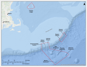
Proposed NE monument

Proposed Marine National Monument in Northeastern Waters of the U.S.

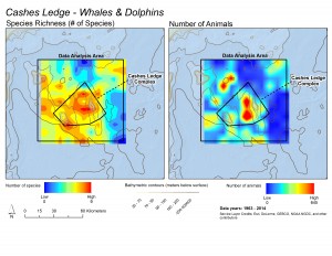
These maps illustrate that while whale and dolphin species are distributed throughout the whole Cashes Ledge region, the deep water toward the center of the proposed monument area is a hot spot for both the total numbers of species (left) and the total numbers of animals (right). Courtesy of Scott Kraus and Brooke Wikgren, New England Aquarium

These maps illustrate that while whale and dolphin species are distributed throughout the whole Cashes Ledge region, the deep water toward the center of the proposed monument area is a hot spot for both the total numbers of species (left) and the total numbers of animals (right). Courtesy of Scott Kraus and Brooke Wikgren, New England Aquarium

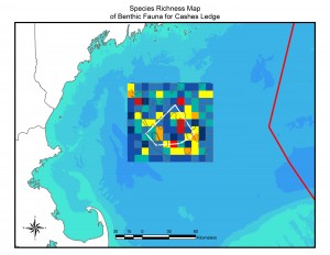
This map illustrates the pattern of species richness (number of species) of bottom-dwelling animals in the Cashes Ledge area. Warmer colors indicate more species. The largest red diversity hot spot is the peak of Cashes Ledge, where the largest continuous kelp forest on Cashes Ledge is located. Note that this map displays number of species, not numbers of individuals or density of animals. Courtesy of Peter Auster and Michel McKee, Mystic Aquarium

This map illustrates the pattern of species richness (number of species) of bottom-dwelling animals in the Cashes Ledge area. Warmer colors indicate more species. The largest red diversity hot spot is the peak of Cashes Ledge, where the largest continuous kelp forest on Cashes Ledge is located. Note that this map displays number of species, not numbers of individuals or density of animals. Courtesy of Peter Auster and Michel McKee, Mystic Aquarium

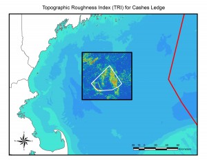
Topographic roughness – essentially, small-scale bumpiness of the seafloor – is linked to the distribution and diversity of microhabitats that in turn support a diversity of species. Warmer colors indicate greater "roughness" and are linked to locations of species-rich communities. For example, the area of high roughness on the top of Cashes Ledge (right inside the proposed monument boundary) is where the kelp forest is located and a species diversity hotspot. Courtesy of Peter Auster and Michel McKee, Mystic Aquarium

Topographic roughness – essentially, small-scale bumpiness of the seafloor – is linked to the distribution and diversity of microhabitats that in turn support a diversity of species. Warmer colors indicate greater “roughness” and are linked to locations of species-rich communities. For example, the area of high roughness on the top of Cashes Ledge (right inside the proposed monument boundary) is where the kelp forest is located and a species diversity hotspot. Courtesy of Peter Auster and Michel McKee, Mystic Aquarium

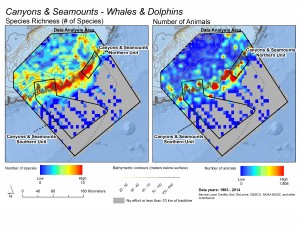
These maps illustrate patterns in the richness of species (left) and total numbers of whales and dolphins (right) observed during surveys in the Northeast Canyons and Seamounts region. Warmer colors indicate greater richness or abundance. Note how species concentrate on the eastern Georges Bank, where the shelf descends into the deep ocean, and hot spots for concentrations of whales and dolphins dot the shelf-edge. Courtesy of Scott Kraus and Brooke Wikgren, New England Aquarium

These maps illustrate patterns in the richness of species (left) and total numbers of whales and dolphins (right) observed during surveys in the Northeast Canyons and Seamounts region. Warmer colors indicate greater richness or abundance. Note how species concentrate on the eastern Georges Bank, where the shelf descends into the deep ocean, and hot spots for concentrations of whales and dolphins dot the shelf-edge. Courtesy of Scott Kraus and Brooke Wikgren, New England Aquarium

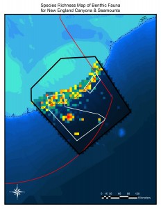
This map shows hot and cold spots for species of bottom-dwelling animals in the New England Canyons and Seamounts areas. Species are especially diverse along the edge of Georges Bank, where the shelf descends into the deep ocean. Hot spots are also visible on Bear, Physalia, Retriever and Mytilus Seamounts. Courtesy of Peter Auster and Michel McKee, Mystic Aquarium

This map shows hot and cold spots for species of bottom-dwelling animals in the New England Canyons and Seamounts areas. Species are especially diverse along the edge of Georges Bank, where the shelf descends into the deep ocean. Hot spots are also visible on Bear, Physalia, Retriever and Mytilus Seamounts. Courtesy of Peter Auster and Michel McKee, Mystic Aquarium

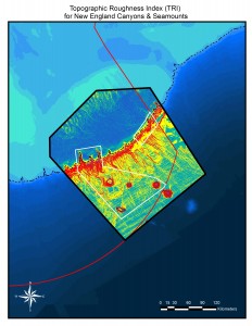
Topographic roughness – essentially small-scale bumpiness of the seafloor – is linked to the distribution and diversity of microhabitats that in turn support a diversity of species. Warmer colors indicate greater "roughness" and are linked to locations of species-rich communities. A high topographic roughness value suggests where especially rich communities may be found. The entire shelf-edge, where Georges Bank descends into the deep ocean, is topographically rough, and Bear, Physalia, Retriever and Mytilus Seamounts stand out. Courtesy of Peter Auster and Michel McKee, Mystic Aquarium

Topographic roughness – essentially small-scale bumpiness of the seafloor – is linked to the distribution and diversity of microhabitats that in turn support a diversity of species. Warmer colors indicate greater “roughness” and are linked to locations of species-rich communities. A high topographic roughness value suggests where especially rich communities may be found. The entire shelf-edge, where Georges Bank descends into the deep ocean, is topographically rough, and Bear, Physalia, Retriever and Mytilus Seamounts stand out. Courtesy of Peter Auster and Michel McKee, Mystic Aquarium

Recent Headlines

  • “A lesser-of-two-evils scenario” – Trade law experts respond to US-China tariff pause
  • Lawsuit filed in effort to protect endangered Rice’s whales in the Gulf
  • Offshore wind revival linked to Trump-backed gas pipelines
  • US finds endangered Gulf of Mexico whale threatened by oil and gas vessel strikes
  • Greens sue NOAA over delayed ESA decision on Alaska chinook salmon
  • OREGON: How tariffs are affecting Oregon’s seafood industry
  • US Wind proposes USD 20 million in compensation funds for commercial fishers in Maryland, Delaware
  • ALASKA: As glaciers melt, salmon and mining companies are vying for the new territory

Most Popular Topics

Alaska Aquaculture ASMFC Atlantic States Marine Fisheries Commission BOEM California China Climate change Coronavirus COVID-19 Donald Trump groundfish Gulf of Maine Gulf of Mexico Hawaii Illegal fishing IUU fishing Lobster Maine Massachusetts Mid-Atlantic National Marine Fisheries Service National Oceanic and Atmospheric Administration NEFMC New Bedford New England New England Fishery Management Council New Jersey New York NMFS NOAA NOAA Fisheries North Atlantic right whales North Carolina North Pacific offshore energy Offshore wind Pacific right whales Salmon South Atlantic Western Pacific Whales wind energy Wind Farms

Daily Updates & Alerts

Enter your email address to receive daily updates and alerts:
  • This field is for validation purposes and should be left unchanged.
Tweets by @savingseafood

Copyright © 2025 Saving Seafood · WordPress Web Design by Jessee Productions